Guest post by dzr1107
Map tips: each color represents a different day. Click a marker to learn more about the spot, and click the star in the map header to save the entire map under Your Places in Google Maps.
Day 1: Denver to Aspen
This trip was impromptu, based on $130 (rt, with carry-on) airfare from both Cleveland International Airport (CLE) and Los Angeles International Airport (LAX). We rented a car and started our drive around 3pm towards Aspen. There were multiple slowdowns while driving on I-70 W through Denver, but traffic was manageable and our delays were only 20-30 minutes total. If we were later, 4-6pm, I would expect significant traffic and allow extra time. Traffic broke outside of Denver (Rt 470 area) and was insignificant for the rest of our trip.
We made one stop in Silverthorne at the City Market grocery store, located right off I-70, to get necessary road trip essentials at cheap prices- water, snacks, and toiletries that wouldn’t fit (or allowed) in the carry-on. We then diverted south on 91 towards Leadville. Route 91 is more or less a two lane road, with passing lanes on uphill climbs. From Silverthorne to Leadville, we were mostly in the mountains; however, once south of Leadville we entered a beautiful valley. We turned west on 82 and began the ascent to Independence Pass. Once we passed Twin Lakes, we entered the White River National Forest, a wide expanse of land that is absolutely gorgeous. I think that it is national park level quality; however, the names weren’t made by a marketing professional. We passed “Lost Man Trail” and “Difficult Campground” which don’t inspire much hope, but make for a good laugh. I hope to make another trip to solely focus on White River National Forest.
There are several pull-offs along the switchback climb to Independence Pass. Speed limits are only 25-45, so this stretch takes a bit of time. At the top of Independence Pass, there is a small parking lot with outhouses, view points, and the photo-op Continental Divide sign. We did notice slight trouble breathing due to the elevation (approx 12000 ft – we were not adjusted). After the Pass, there is still about an 45 minute drive to Aspen. I believe also that the Pass is more scenic from east to west rather than west to east. Also, this stretch of road does close in the winter.
We arrived at Aspen near dark (7:30ish). The downtown of Aspen is a grid pattern with a few one way streets and pedestrian streets. Parking is primarily paid parking on the street, with several zones of permit only parking and no overnight parking. Pay attention to this because police do give tickets (we got a warning). We stayed at the Independence Square hotel, managed by Frias Properties. From what I gather, each room owned by individual people and rented out through a central broker (Frias). I found the rates to be reasonable and the room to be very nice. Aspen, as a whole, is a very expensive city – from hotels, to shopping, to restaurants. It is, however, very quaint, friendly, safe, and filled with gorgeous flowers. We had dinner and a night cap at Little Annie’s, a very cute pub with good beer and reasonably priced good food.
Day 2: Maroon Bells and Black Canyon of the Gunnison
We started our day driving to Aspen Highlands, a 10 minute drive from downtown Aspen. Once you get close, it is well marked to find Maroon Bells parking and bus tickets (there’s a small ski store and restrooms). You must take a bus from 8 am – 5pm (adults $6, 0-5 free, 6-16 and 65+ $4). Busses start at 8:05 and run every 20 minutes. We took the 8:25 bus and plenty of seats were available. It’s approximately a scenic 15 minute bus ride to the small parking lot at the top. Once dropped off, we stopped at the ranger station to get a brochure/map of the area and took a short walk to Maroon Lake. I do not have the vocabulary to describe the breathtaking beauty of this area. If you have the opportunity to visit Maroon Bells, do it. The Bells (twin peak mountain ranges) are reminiscent of Glacier National Park. We took the Maroon Lake Trail (1 mile) around Maroon Lake and then added the Scenic Loop Trail/Upper Lake trail (1.5 miles). If pressed for time, I would skip the Scenic Loop Trail; however, much of this is because the lake bed was dry when we visited. These trails are both easy, but narrow at spots. My next visit, I will try the Crater Lake Trail, which is 3.6 RT hike to a lake closer to the Bells. Note, the campground at Crater Lake was closed due to consistent bear activity. We left on the 10:10 shuttle, which was full coming up to the Bells, but there were only 3 of us for the return trip.
It took us approximately 3 hours to drive from Aspen to the Southern Rim of the Black Canyon of the Gunnison. We took 82 north to Carbondale, south on 133 to Hotchkiss, west on 92 to Delta, and 50 south into Montrose, where we then followed signs for the NP. All these roads were single lane, with specified passing areas and very little traffic. There are numerous pulloffs, including one after a mountain pass that shows rolling “muddy slumps.”
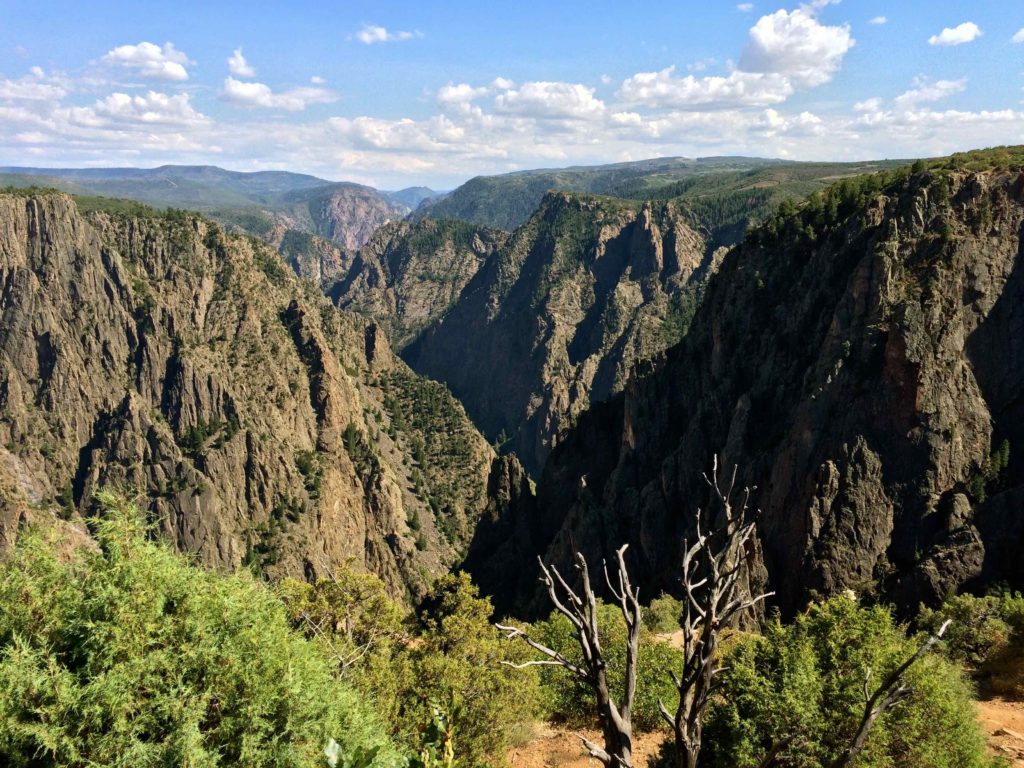
Much like the Grand Canyon, there are two rims to the Black Canyon of the Gunnison, with the southern having many more view points. In the interest of time, we skipped the northern rim and only saw the second. I do not feel like I missed anything, but I’m more of a mountain person than a canyon person. There is no running water (aside from the river) at the park, so be prepared for outhouse restroom facilities. It took us about an hour and a half to visit most of the pull offs on the Southern Rim Road. Several of them have short walks to get to the actual view point. The longest walk is a 1.5 mile trek out to Warner Point, which was scenic; however, I’m not sure I’d do it again. In addition to the road that goes along the rim, there is the East Portal Road that takes you to the bottom of the canyon. We decided to plunge into the depths of the canyon. It’s about a 15 minute one way drive; however, this is because its a 16% grade. It is encouraged to use low gear, but we didn’t really know how to do that in the rental so we tried the “bump the brakes, ignore the speed limit, and hope for the best” approach. When we parked at the bottom, the brakes were not 100% and it smelled strongly of burning rubber. My bad. We took our time having a nice picnic and reading about the Gunnison Tunnel, a civil engineering landmark. Going up the road was much easier.
We then drove the approximate hour to Gunnison and passed through the Curecanti National Recreation Area. This is a large dam/lake/reservoir area of the Gunnison River and looks like it would be a lot of fun if you were into water sports. I am not.
Day 3: Great Sand Dunes NP and Colorado Springs
- Great Sand Dunes National Park and Preserve
- U.S. Olympic & Paralympic Training Center
- Garden of the Gods
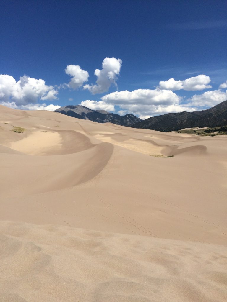
We woke up and started the 2.5-3 hour drive to Great Sand Dunes National Park. To maximize our mountain time, we chose to take 50 into Poncha Springs, south on 17, and then east on Lane 6. Once on 17, we were essentially in a giant, sparse valley. Lane 6 is a very small road (although well marked for the park) lined with cattle guards, and has a mind-boggling 55 mph speed limit (maybe it was 60, but it really should be 75). We stopped at the Oasis Store, which is a hard to miss place that has a small sign and sits up from the road into the park. It is the only location to rent sleds and sand-boards. We stopped and rented our sled ($21/day) because we decided it makes no sense to visit sand dunes without sledding.
It is only $3 to enter the Great Sand Dunes National Park, but that is simply because there is not a lot of upkeep to the park. There’s a visitor center that explains the creation of the sand dunes (spoiler: opposing wind currents), a rustic campground, and picnic area. Once we parked at the dune parking lot, we were essentially dumped into a flat firmly packed portion that had a tiny trickle of water (toe high). It is a free for all, so we looked for an area of the dunes that didn’t have people and set forth. It is totally awesome to be on sand dunes surrounded by mountains, except for the fact that it’s a lot of walking uphill in mushy calf-burning sand. We also visited at high noon, so we could not walk barefoot and needed our hiking boots to protect our feet. We only went approximately 1/3 up the dunes, but I imagine the view is pretty cool if you make it to the top. We found it more fun to sled. I was surprised to find out that even if you sled down properly, stopping creates a little wave of sand that crashes all over you and gets about everywhere. Keep your mouth closed. If you sled improperly, the wipe outs do not hurt.
We only stayed for about 1-1.5 hours and then continued our drive to Colorado Springs. After we left the park, the drive became less scenic and lost a bit of fascination once we got on I-25 north. We stopped at the Olympic Training Center in Colorado Springs, but it’s closed on Sundays. We were able to view a small museum and gift store. I would think the tour would be interesting, but I think it would be best as an addendum and not a focal reason to visit Colorado Springs. Since it was closed, we drove 10 minutes to Garden of the Gods.
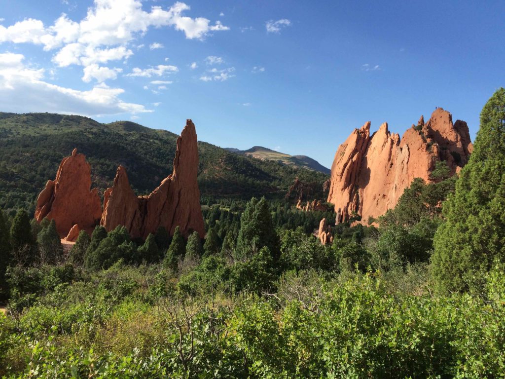
Garden of the Gods is impressive, but it was very crowded on Sunday afternoon. This was my second time visiting the park and I enjoyed the less crowded original visit (I think it was a Wednesday morning) over this time. The park has nice walking trails around massive red rocks jutting from the earth. With the correct permit you can rock climb, but everyone is going to crowd around and watch you. It is still worth the stop, especially if you are doing this route or Pike’s Peak.
We then continued our drive to Denver and stayed a hotel close to the airport for early morning flights. We were advised to arrive at the airport two hours early, however; I dropped my brother off at 6 am for his 8 am flight and he had more than enough time to get through security and get to his gate.
Traveled in August 2015
Leave a reply