
Guest post by dzr1107
Map tips: each color represents a different day. Click a marker to learn more about the spot, and click the star in the map header to save the entire map under Your Places in Google Maps.
Day 1: Manzanita Lake
We flew out from Ohio the day before and stayed the night with relatives in Berkeley, allowing us to be well rested and ready to begin our road trip to Shingletown, CA in the morning. The drive, in theory, should take about three and a half hours. The traffic around San Francisco airport and the greater Bay area can be a little overwhelming, but it’s not as bad as other major cities. Once you get on the other side of the hills, traffic lets up significantly and it is relatively smooth sailing for the rest of the way. We rented a charming house in Shingletown, which is 15-20 minutes from the North end of the park. It was delightful, however most of the hiking that we were interested in was on the Southern side of the park.
Side note – Lassen Volcanic National Park is pretty large and there’s only a road that goes through the western side of the park. To explore other regions like Butte Lake (we did), Drakesblad (we did not), and Juniper Lake (we did not), you have to drive outside the park and enter. The north side is better for Butte Lake/ Cinder Cone and numerous other region activities, the south side is a better “bang for your buck” if you’re short on time and want to see a lot.
At the advice of our AirBnB house owner, we got all of our food for the next few days at a grocery store in Anderson, CA before we turned off. There are very limited markets in Shingletown – although you’re fine for the staples, which for me are beer, water, and bread.
Since we got into the house mid-afternoon, we decided to drive to the park and walk the 1.5 mile loop trail around Manzanita Lake. You can pull off the main route in several spots to pick up the trail (starting immediately inside the gates), or park at the Ranger Station / Loomis Museum. It’s a very level and easy trail that goes lake side, into the forest, and by campgrounds for some scenic shots.
Day 2
- Lake Helen
- Bumpass Hell
- Sulphur Works
We started the day early (and early is about 8 am. Maybe 8:30. Definitely before 9.) and drove through the park, stopping at The Crags (a million craggly jumble of rocks from when Lassen blew), Hot Rock (a really big hot rock that flew a few miles), and Lake Helen.
Side note – Lassen is a very special place in the world because it contains all four types of volcanos. I imagine a geologist would be all about this place. I found it really cool, so I’ll apologize for my simplistic descriptions of rather mind-blowing rock stuff.
Lake Helen is gorgeous. It’s a good place to have a picnic lunch (we did) and conveniently enough, it has the beloved national park outhouses. There were a few people swimming there while we were eating, which seemed like a very cool idea to do. But I’m not that cool, so we ate a lot of food while we watched people get helicopter lifted off Lassen Peak trail.
Our next stop on the route was Bumpass Hell. If you go to the park, you sort of HAVE to go here. We made an concerted effort to get to Bumpass Hell early in the day (ok, noon) because other reviews indicated it can get crowded. And it was crowded. All 30 people. At once. The nerve. BUT, Lassen is so remote and heavenly peaceful and uncrowded, that this really did feel crowded. Depending on your physical condition, the hike isn’t “easy” but I wouldn’t say it’s difficult. It starts off with a long and minor uphill walk through some woods and around a few ridges, providing some good panoramic views of what was once the center of a really, really big volcano. It’s only 200 feet elevation gain in about a mile, but for some reason it didn’t seem that easy. There’s a few things you can do with the trail – you can hike to the Bumpass Hell overlook (which is great, but you made it that far so you’re really probably not going to stop and turn around here), hike down from the overlook to the boardwalk (the most significant elevation change of the hike), or use it to connect to a few other trails (Cold Boiling Lake, Kings Creek Picnic area). Most people, including us, hike to the board walk and back.
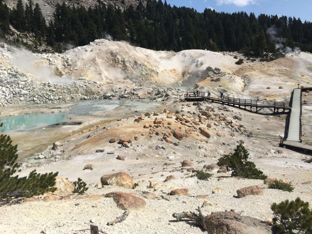
There are signs everywhere, but I do safety for a living, so I’ll make the point here too: do NOT go off the boardwalk. Not the tip. Not for a second. Don’t see how it feels. The boardwalk is suspended over a very fragile and thin surface, with really hot boiling water/earth stuff trying to escape. In fact, it IS escaping in the mud pits and pools all around you. It’s named after the dummy who lost a leg because he fell through the surface. Twice. (I still don’t know how they built the boardwalk). As long as you keep an eye on kids, they’ll be safe. Just pay a little attention. Also, the sulphur smell is there but it’s not so overwhelming that you want to heave into the boiling mud pool.
We continued our drive to Sulphur Works, which is a giant bubbling hot mess on the side of the road. We ended up at the visitor’s station on the south end of the park and got some ice cream. We then drove straight home through the park, stopping only at Summit Lake (which can’t compare to Lake Helen). This drive with stops and the hike at Bumpass Hell took us pretty much all day and I’d say it’s about an hour and a half one way without stops.
Day 3
- Lassen Peak Trailhead
- Terrace Lake
- Shadow Lake
This hike. Let me tell you about this hike. It’s a mere 5 miles round trip. Easy, right? Just a little 2000 ft elevation gain in those quick 2.5 miles, no biggie.
We did get up early so we could drive about 45 min-hour to the start of Lassen Peak trail, where there are outhouses and a pretty big parking lot. We stopped at the north Ranger station though just to check the weather. It’s a good idea because 1) yesterday we watched helicopters snatch a person and 2) the weather can be different in all areas of the park, and especially at the top.
The trail starts with a straight uphill path to a nice little informational board. If you’re like me, you’ll be second guessing why you agreed to this hike and have already taken five pictures because “it’s so pretty” when you’re really catching your breath before you get to it. You’ll look up and see a point though and think that’s not so bad, we’re just going up there. Spoiler, you can’t even SEE where you’re going from here. The trail then goes directly back the way you came, except you’re just going up. Forever and a day. Get used to switch backs. And the sun, because there is no shelter once you’re out of the first little stretch.
The first mile or so is not too bad. They’re long switch backs with a really scenic view of Lake Helen. You can also see for quite awhile on the horizon. Usually my hiking is in the mountains, so you can’t see forever, but Lassen Peak stands much taller than the surrounding area (9th highest peak in the Cascade range). There’s eventually a point, and I can’t remember when, but you really start to hate life. I believe it’s when you’re at the base of steps leading up the spine of a ridge with snow. Yes, snow. In August. In sunny, hot, draught-struck California, snow. Once you hit these steps, it’s short 45 degree switch back after 45 degree short switch back until you contemplate how you can get a helicopter ride yourself.
The other component to these short little masochistic switch backs going up a spine of a volcanic peak, is the wind. As I mentioned, there’s nothing around it stopping the wind. It actually got bad enough that I was a little bit afraid on the top switch backs, because there’s nothing to hold on to and the wind was to the point of blowing me around a little bit. At the very least, bring a good pair of wrap around glasses. My aviators weren’t doing a thing against the wind, but man I looked great.
The top of the peak – rather, the faux peak – gives 360 panoramic views, including a glimpse of Mount Shasta (115 driving miles away). Words can’t really explain it, and by now you know I’m wordy. The unsanctioned? trail continues from this point, across some snow to another peak. There is not so much a “trail” up the rocks to the peak, but it’s still manageable. There is nowhere higher to go at this peak and it’s marked with a US Coast and Geodetic survey marker. At this point, most people revel in the beauty. I did too, until my thoughts were consumed with the ridiculous wind and a tiny voice saying “you know, there were only two volcanic eruptions in the 20th century.. and this was one of them… lovely day, isn’t it?”
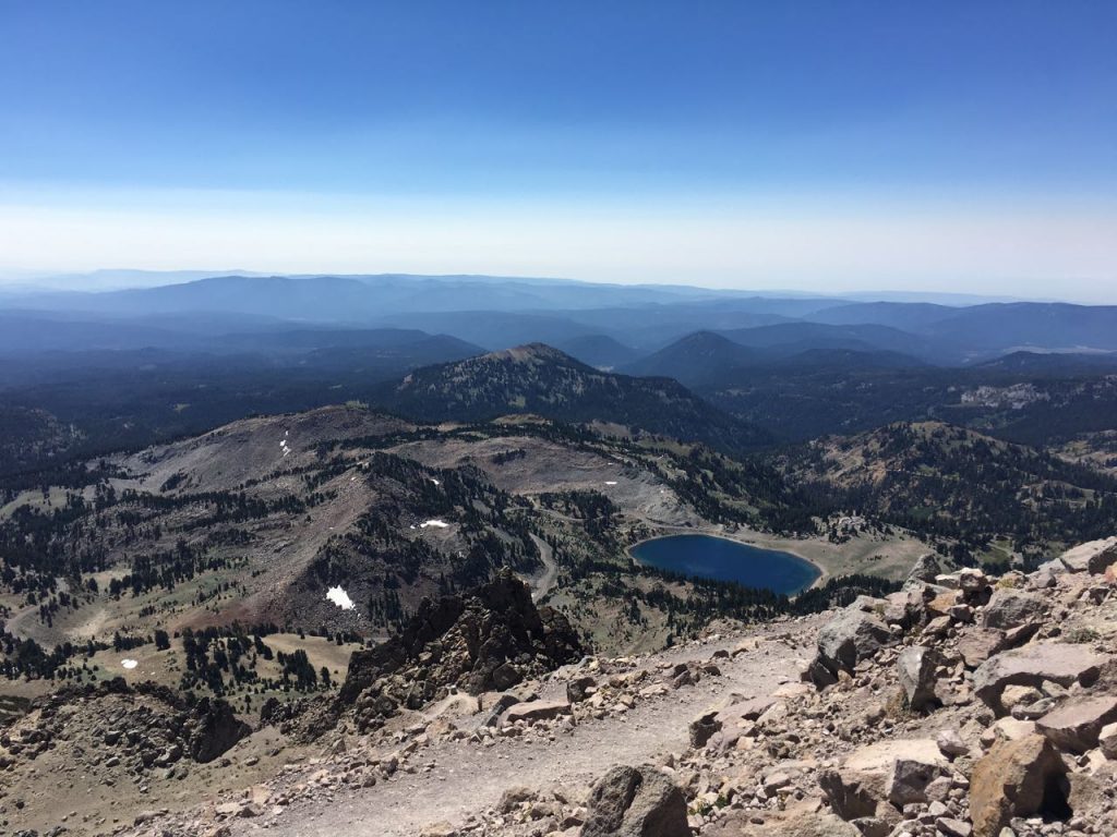
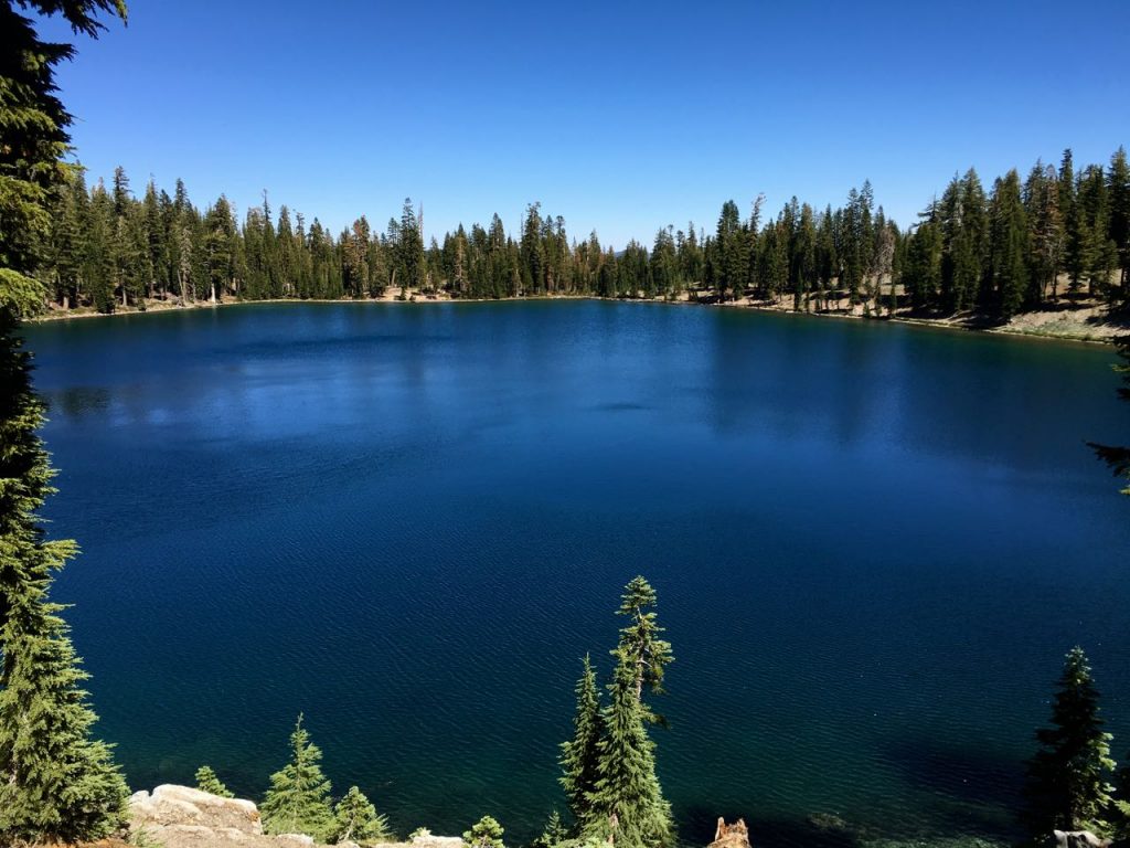
On our hike back down, we kept staring at a large beautiful blue lake – not Lake Helen – and trying to figure out what it could be. Once we got a park map, we realized it was most likely Shadow Lake, and it looked to be a short 1.6 mile hike from the road – and from the top of the peak, it looked pretty flat. We (I) decided this would be a great place for a late lunch, and we pulled off the side of the road and started the hike.
This hike does provide some shade, since you go DOWN a grove of trees to to Terrace Lake. This lake is pretty, but it’s like the pretty sister compared to the model sister. Lovely lake. Can’t compare to Shadow Lake. This lake is probably similar to Lake Helen, except I loved it a whole lot more. It just felt like a private little tiny sliver of paradise with perfect blue water, the fresh cedar smell, and a little volcanic peak from hell as the backdrop. We had lunch there and spent a good bit of time taking in the scenery. During this time, and our hiking to and from, we passed only four people.
Day 4
- Cinder Cone
- Tahoe City
I’ll preface this by saying I was a little cranky this day – tired from work, doing all the driving for the trip, and hiking up a volcanic peak the day before.
There are several different routes to take and we chose to go 44 to 395 to Reno. We did make a morning stop at Cinder Cone, located in the northeast area of the park. To get to this area, you have to drive down 7 miles of gravel road. Go slow (ish, it’s a rental) and keep the windows up. Once you get to the park, there’s a few cabins, a few restrooms, and a parking lot. There’s a few trails that go off east of Butte Lake, but we were here for Cinder Cone.
The trail to Cinder Cone is relatively flat with a few uphill sections. This normally wouldn’t be bad, but the trail is predominately cinders. It’s like walking in sand, unless you can find a packed down area. The trail goes along the Fantastic Lava Beds, but to me in my cranky state, it looked like a pile of rocks someone had to bulldoze out of the way to build, I don’t know, a parking lot and a few cabins. The Painted Rocks aren’t all that colorful either.
I stopped once I got a glimpse of Cinder Cone, which is a rather impressive perfect cone shape. Other members in my group continued and hiked up just a little bit on the cone. They said it was difficult because for every step forward they took, they slid backwards. It sounded like torture to me, and I think I made the right choice.
The drive to Tahoe takes about 3.5 hours, aside from our side journey. For the most part, it’s very rural and relatively scenic. We had lunch in Susanville, at the Frosty Mill.
In Tahoe, we stayed Tahoe City and rented from VRBO. We picked up our keys, got groceries, picked up a local pizza, and relaxed on the deck with lake views.
Day 5: Drive around Lake Tahoe
The drive around the lake takes a few hours and does not always have lake views. We drove south along Emerald Bay, which was pretty congested with people. We stopped in South Lake Tahoe and parked in a large parking garage behind the Marriott. We then got tickets for the Heavenly Gondola, a whopping 2.4 mile gondola ride. There is a nice observation deck on the way up (only on the way up) which features panoramic lake views, informational points, snacks, and restrooms. It’s worth the pause in the ride. At the top of the gondola, there’s several little festival-like features – a climbing wall, some kid slide thing, and a few other things (I didn’t pay too much attention). There’s also a ski lodge open for food if you’d like lunch or to use the restroom.
You do (if you select the option when you get tickets and sign a waiver) have the ability to get on another ski lift and go to the peak of Heavenly. We did this and walked around the little top deck and up and down a few ski trails. Members in my group were scoping out the runs for a return ski trip in February.
The gondola provides a great perspective of the lake in its entirety and is an entertaining option for all ages. If you want to see Tahoe while relaxing, it’s worth it, but I wouldn’t say it’s a must do.
We had lunch and checked out the shops at the base of the gondola. The rest of the drive was relatively unremarkable. We didn’t research the stops we wanted to make, and since we were headed counterclockwise around the lake, most of the scenic pull offs were on the opposite side of the road and there was too much traffic/parked cars to make it work. If I did this again, I’d go clockwise around the lake.
We spent the evening on the porch. I should note that in Tahoe, or at least Tahoe City, they have a problem with bears breaking into homes. You have to be very careful with how you store your food. The house we stayed at actually had electric bear mats that we had to turn off before we could step on it because a bear had previously entered their home.
Day 6: The Rubicon Trail
I had heard wonderful things about the Rubicon Trail (the walking one – I believe there’s also an off roading trail to make things confusing). We parked at DL Bliss and parked at the first parking lot we saw – which was wide open early in the morning (again, 8ish). We wanted to hike to the lighthouse and then down to Emerald Bay, but we had a little difficulty actually finding the proper trail. We were on a trail, but it was in the middle of the woods and just didn’t feel well marked. We eventually (after a mile) stumbled on what was the Rubicon Trail and found the lighthouse.
Don’t go out of your way to see the “lighthouse.” Perhaps it’s because I’m more east coast and when I think “lighthouse” I think of the stately lighthouses on the Maine coastline. This isn’t it. Actually, if I didn’t have a map, I’d think it was an outhouse. Seriously. I should have googled it beforehand. Google it now, I’m not kidding.
The trail itself is really pretty nice and shaded. You walk predominately in the trees along the lake. The shoreline reminded others of Maine. It’s relatively flat, which makes it nice to stroll or to powerwalk and while you passed a fair amount of people, it didn’t feel crowded. It’s a hard act to follow after Lassen, but it was very relaxing and serene. We did not walk down to Vikingsholm or the other parking lot in Emerald Bay, mostly due to our pre-hike hike to find the correct trail. Ideally you’d get dropped off at one location and picked up at the other.
Once we got back and recovered a little bit, we drove up to Squaw Valley, home of the 1960 Winter Olympics for dinner. There were several restaurants open in the ski village and several retail stores. We preferred this because it was less crowded than Tahoe and we’re sort of ski nerds and like to obsess over different warm weather fabrics. It was also cool because my parents could remember watching the Olympics at Squaw Valley.
After we returned, we walked on a beach in Tahoe City and took pictures of a gorgeous sunset.
Tahoe is definitely a gorgeous place and an outdoor enthusiast paradise, but I do not feel we really captured its essence. We don’t enjoy crowds, so we shied away from the nightlife and the busy touristy stores. When I go back (I’d still totally go back), I’d check out Desolation Wilderness and look into some of the other state parks beyond DL Bliss and Emerald Bay. A house with a lake view is a must though – nothing beats a cold beer on the deck at sunset.
Day 7: Donner Pass
This was essentially a travel day. We left Tahoe City and stopped at Donner Pass right off of Route 80. We only checked out the small museum and statue. It’s a little weird to think of what they went through to discover the West and then to realize you’re standing where cannibalism took place… especially when you’ve spent a week with family. Just kidding.
Traveled in August 2016
Leave a reply