Map tips: each color represents a different day. Click a marker to learn more about the spot, and click the star in the map header to save the entire map under Your Places in Google Maps.
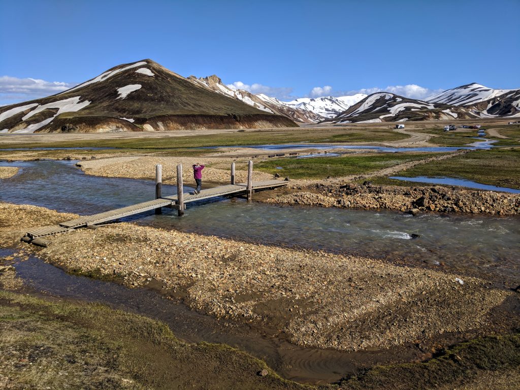
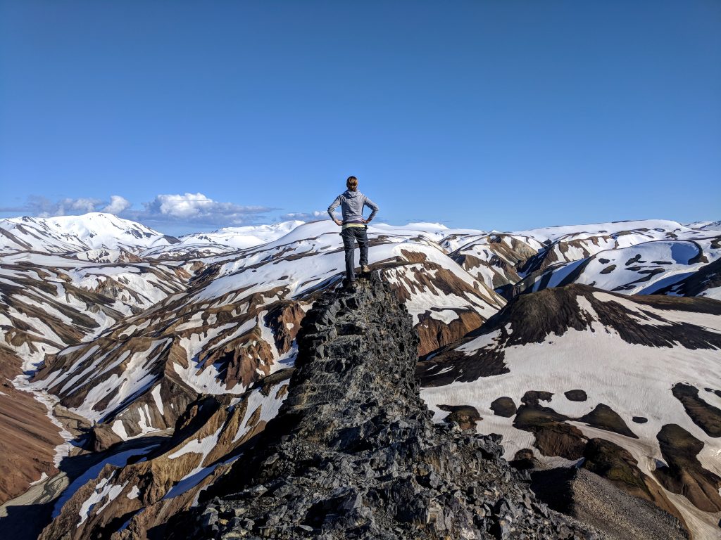
Day 1: Landmannalaugar
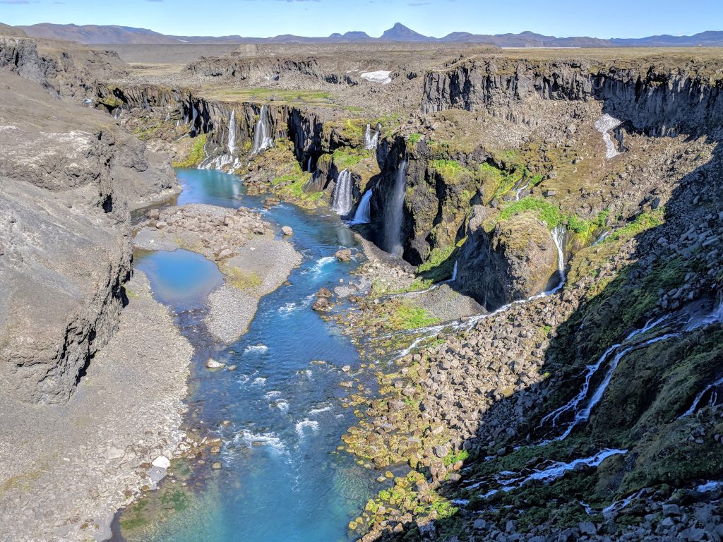
- Sigöldugljufur
- Bláhnúkur
Our flight to Iceland arrived around 10:30 AM, got our rental car (through Orange – more on that towards the bottom) and were on the road around 11:30. The weather was unbelievably beautiful – they said it was sunny around the whole island, which is very rare, and it wasn’t sticking around.
We planned on going into Reykjavik and then driving to Vik with a few stops. But, we had to take advantage of the weather so we made the very long drive to Landmannalaugar. Since there was almost 24 hours of daylight, it didn’t matter that we were getting such a late start. We grabbed lunch in Keflavik and then started the 4-hour drive.
There are 3 ways to get to Lanmannalaugar (which is considered the highlands of Iceland) and we took the safest/easiest route, which was 32 > F26 > F208. 26 and 208 are F-roads, which means they’re not paved and you can’t go on it without AWD. It also means it’s a slow drive because there are lots of potholes.
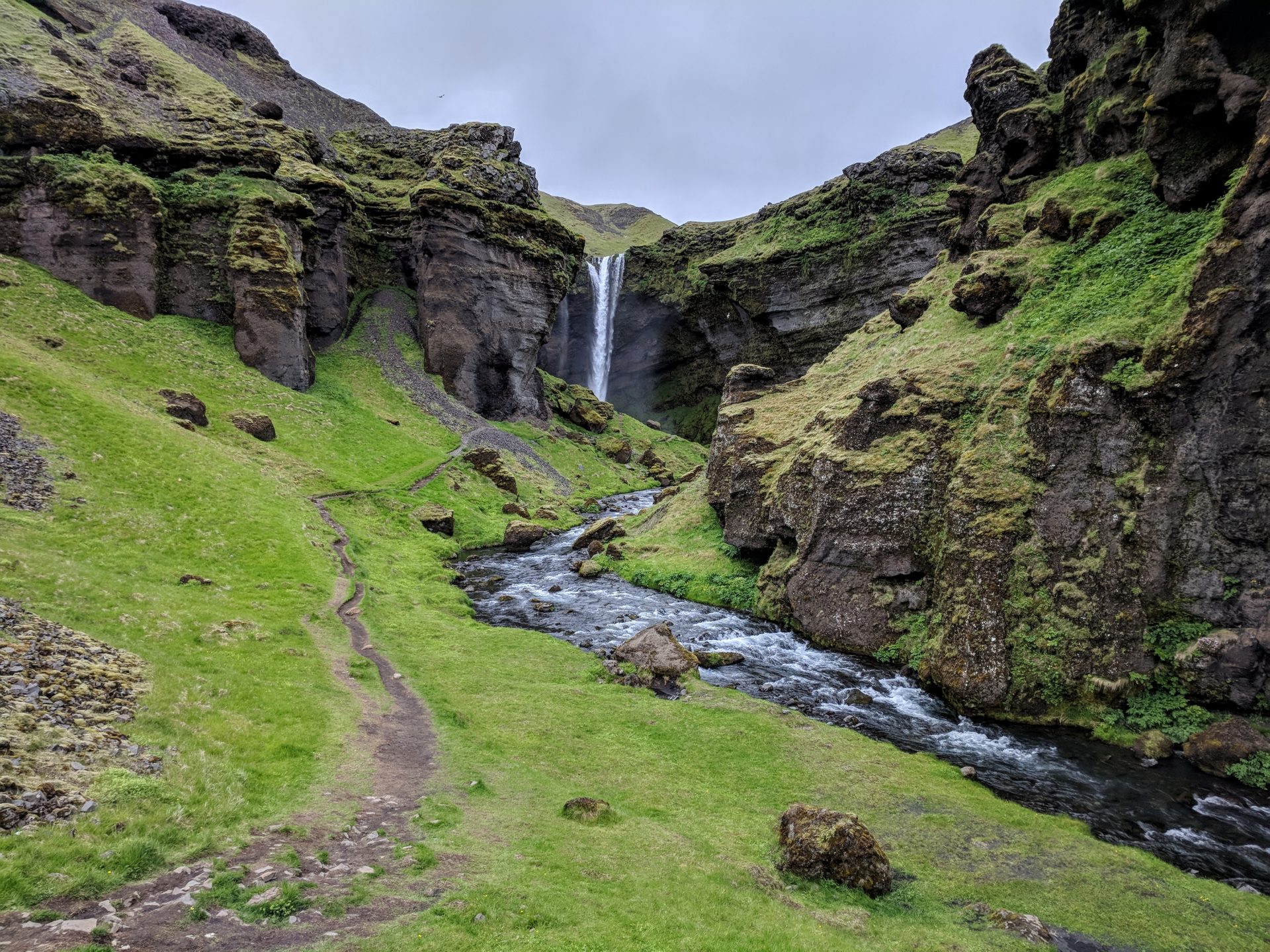
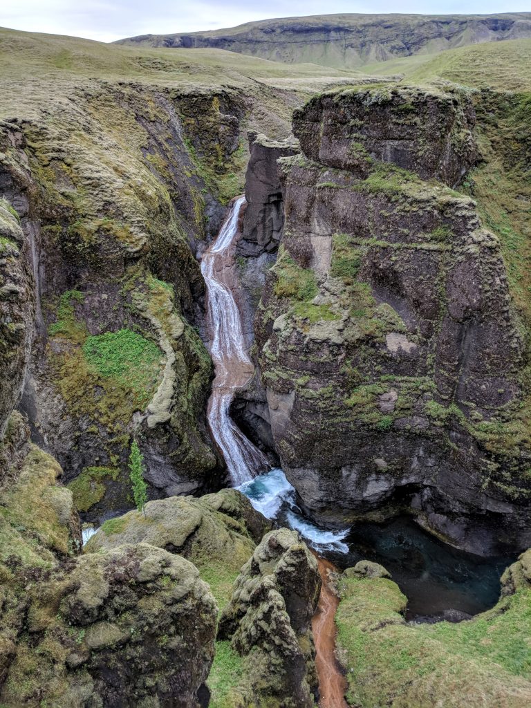
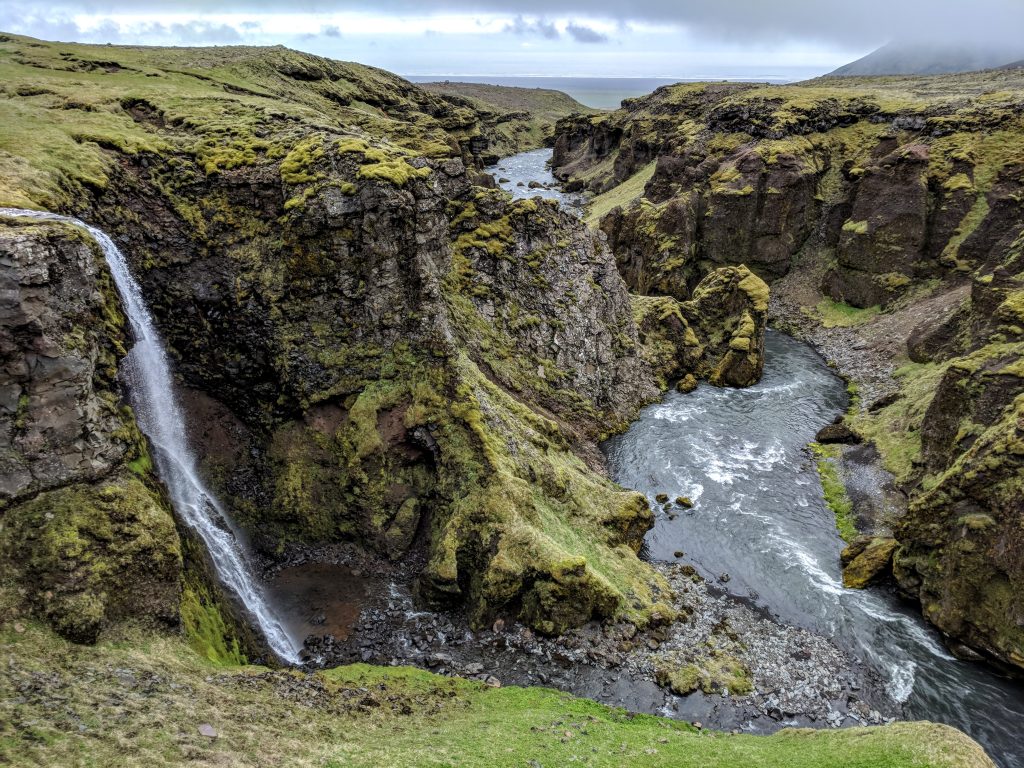
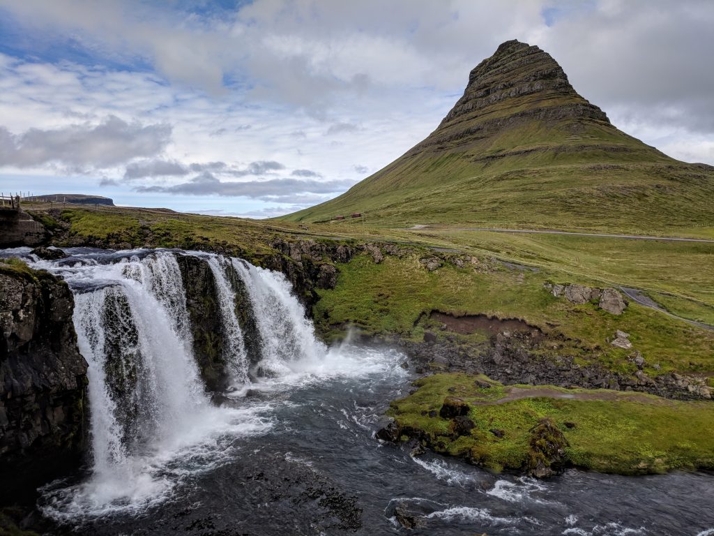
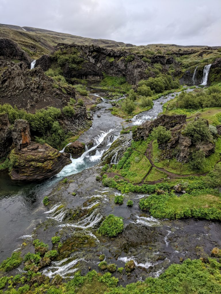
Our first stop was Sigoldugljufur, which is a jaw-dropping canyon where lots of waterfalls just fall out of the side. There are no signs but is on Google Maps. On 208 you’ll pass a power plant and shortly after that go down a short but steep hill. Just after the hill, there’s a dirt road to the left that has a sign that says “Staff access only.” You almost have to look back over your shoulder to see it, and there is an area to park on the other (right) side of the road. Walk along that restricted road for about 10 minutes and you’ll find the canyon to the left. We spent about 30 minutes here and didn’t see another person. One of the coolest places of the whole trip and a perfect introduction to Iceland.
Then we drove into Landmannalaugar. 208 ends there, so you just keep following signs at any intersections. There are no river crossings until the very end, but you can park before it (definitely do that) and take a small footbridge over to the camping and hiking area.
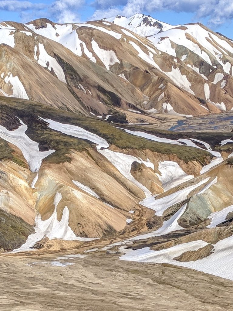
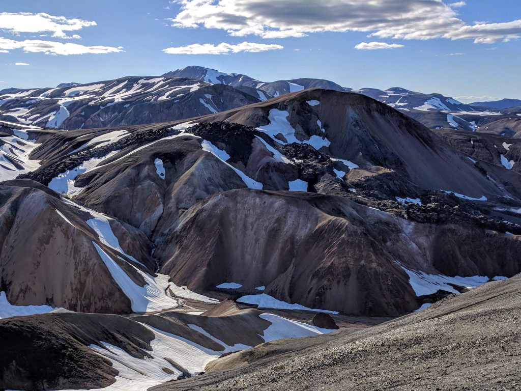
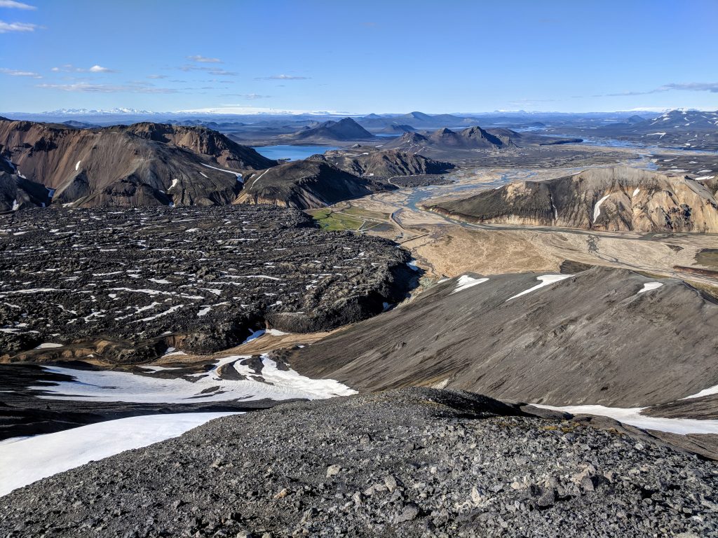
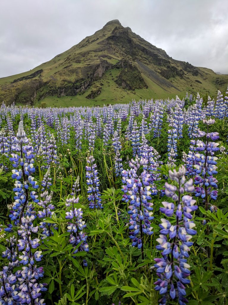
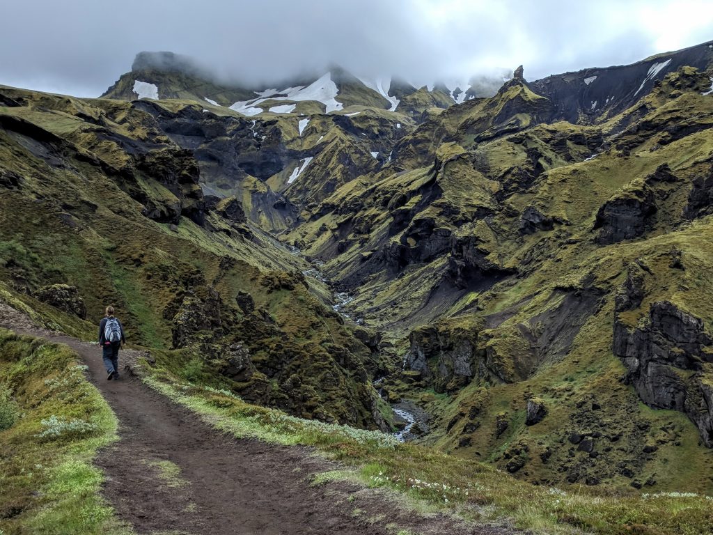
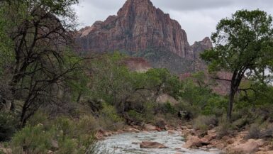
We did the Blahnjukur (aka Blue Peak) loop, and the views were spectacular. It’s a short, steep ascent up and you can go back down the same way for a < 1 hour hike, but we did the loop coming down the other side through the lava fields – 5 km, 2-3 hours. We were going to go to the top of Brennisteinsalda, too, but it had already been a long day and we still had a 3-hour drive. Brennisteinsalda is the one that has all the different colors, but unfortunately was already in the shade so we didn’t really get to see them. It seemed like it would be cooler looking at it than from it, anyways.
Made the long drive to Vik, where we were staying 3 nights at Kosy Vik – wonderful place. Hrund is the host and is so helpful. Makes a huge breakfast in a basket each morning, so you can either take it on the go or have breakfast in bed.
Awesome start to Iceland.
Day 2: Vik to Jokulsarlon and back
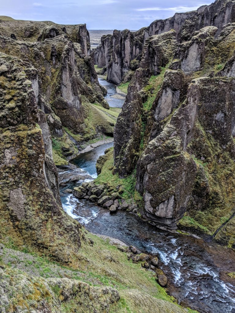
- Fjaðrárgljúfur
- Diamond Beach
- Jökulsárlón
- Fjallsárlón
- Svínafellsjökull
- Svartifoss
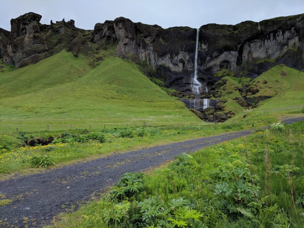
- Foss a Sidu
This was possibly the best day of scenery I’ve ever had. There are so many stops on the way to Jokulsarlon, and our first was Fjadrargljufur. It’s about an hour from Vik and one of the things I wanted to see most. Awesome, eerie-looking canyon. There’s an easy 2-mile RT path along the top of the canyon, and you don’t really need more than an hour here. The best view is from the end looking back down the canyon (the first picture below).
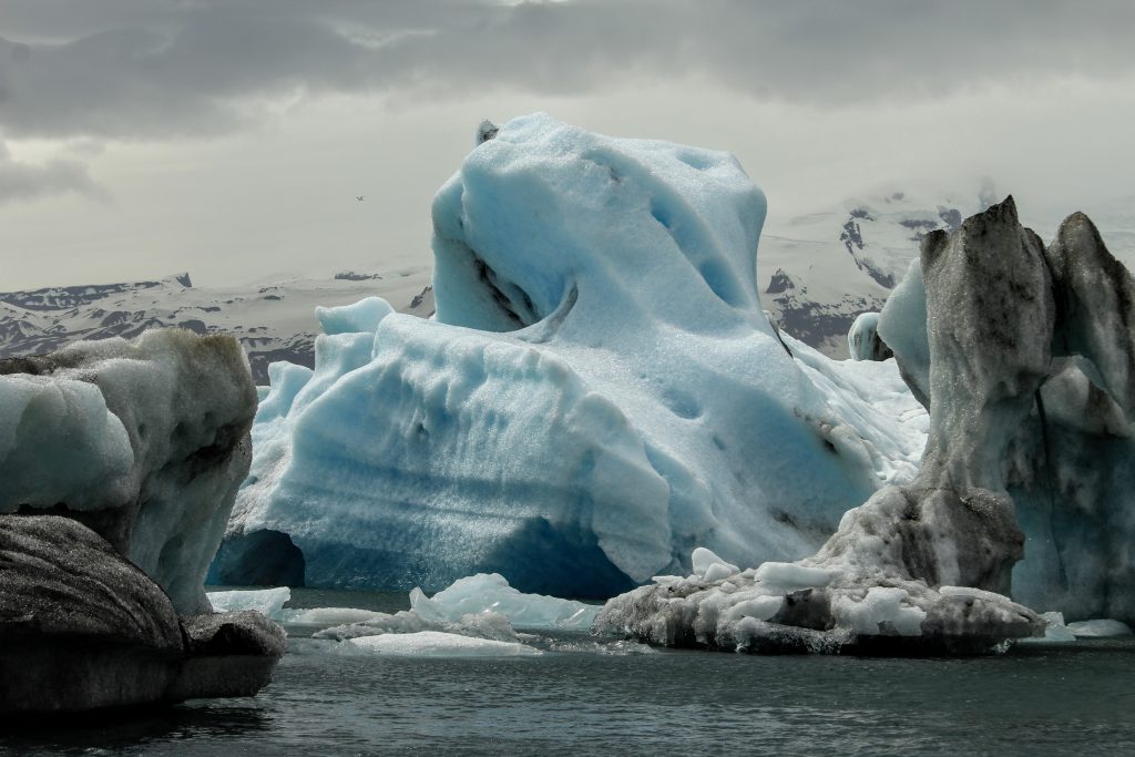
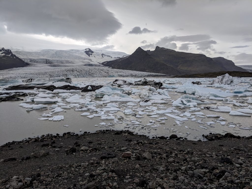
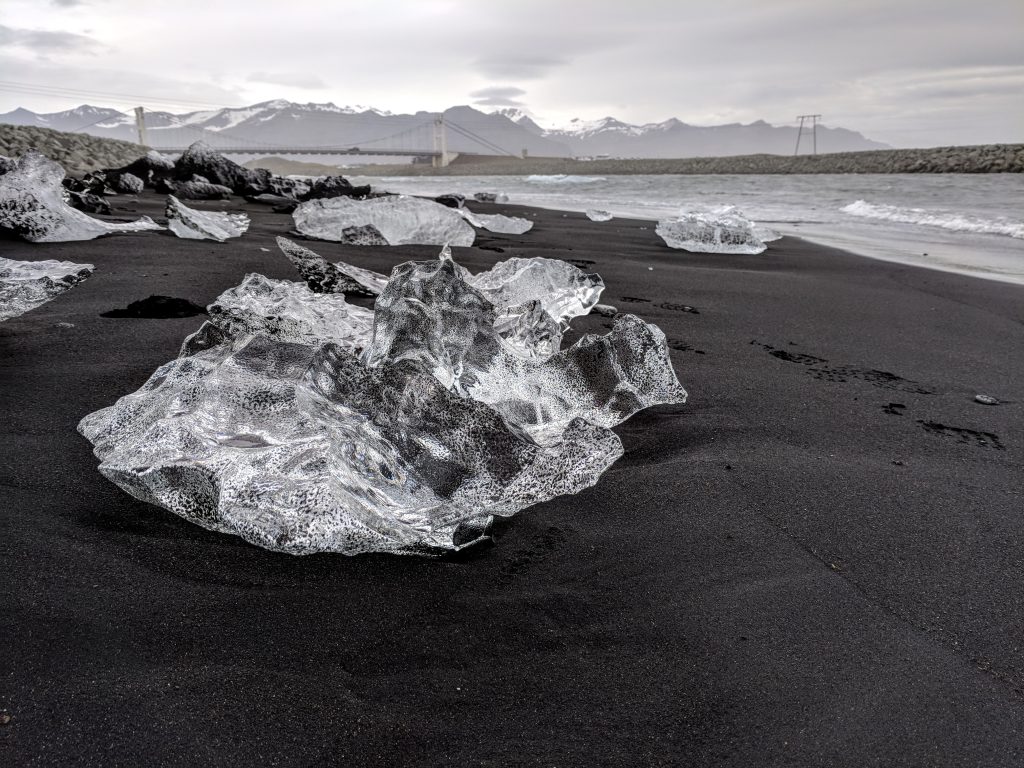
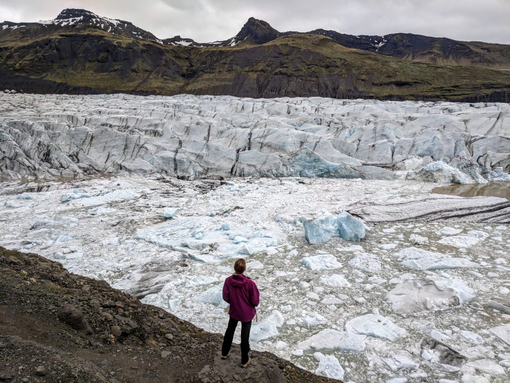
We then went straight to the glacier lagoon, Jokulsarlon, which was another hour and a half from Fjadrargljufur. We made a few quick stops for pictures along the way, and it rained on and off a bit. There is a large bridge that you cross, and just after it the Diamond Beach is on your right and the glacier lagoon is on your left.
We went to Diamond Beach first and explored both sides. The contrast of the pieces of glacier on the black sand beach is beautiful. We saw a seal playing around out by the bigger chunks of glacier, too. Then we walked along the coast of the lagoon for about 30 minutes. It is so much better in person than what we expected from pictures. We opted not to take a boat tour because of time and money, and thought walking around was just fine.
Heading back to Vik, our next stop was Fjallsarlon, which is another glacier lagoon. It’s pretty close to Jokulsarlon and well-marked – you can’t miss it because the glacier is huge and it’s all you’re looking at while driving west. It’s similar to Jokulsarlon but different enough that it’s worth a stop. We had some soup at the café there for lunch.
Just before the Skaftafell area of Vatnajokull National Park there is a marked road to Svinafellsjokul. The road is terrible, but not too long. You can hike up the side trail for a while, but we just did about 10 minutes or so to get to the point where you were really close to the glacier. Don’t know if it’s necessarily worth it, but neat.
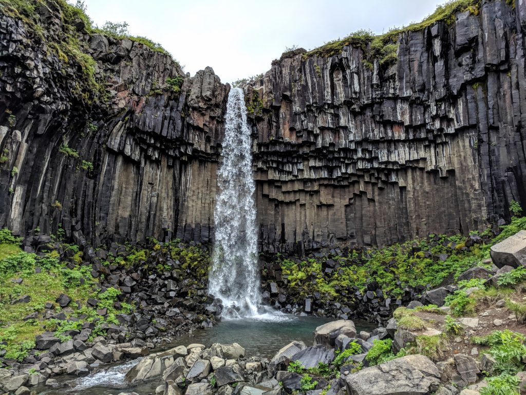
Next was the 2-mile RT hike to Svartifoss, which is in Skaeftafell National Park. This was the only place we had to pay to park ($6 USD). It’s an easy, quick hike and the waterfall is very unique with the basalt columns. Only need about an hour here, unless you’re hiking further to the glacier.
The weather got worse the closer we got to Vik. We passed Systrafoss but chose not to get out and take a picture. Did stop at Sidufoss for a quick shot because it was right off the road. We got dinner at the Vikurskali Grill, which is attached to the gas station in Vik. Reasonable prices, huge portions, and good food.
Day 3: Fimmvörðuháls – Read the in-depth Hike Guide here
- Skógafoss
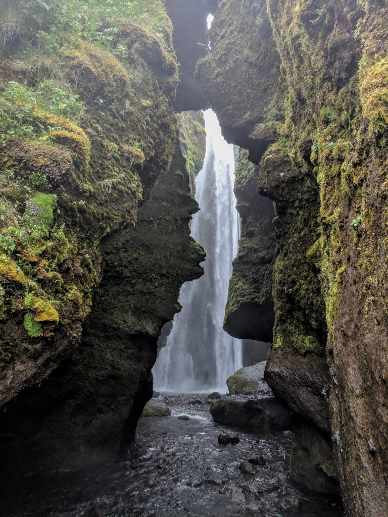
- Gljúfrabúi
- Seljalandsfoss
- Fimmvörðuháls
- Kvernufoss
- Reynisfjara
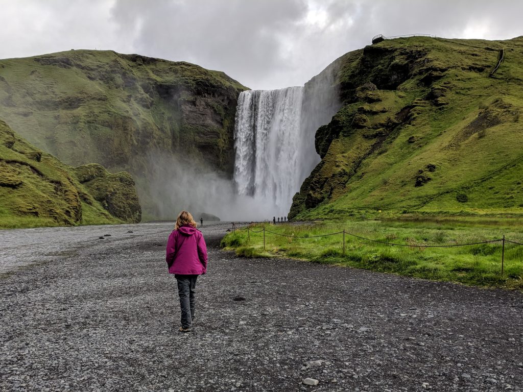
If day 2 wasn’t the best day of scenery I’ve ever had, then this was. Iceland is unbelievable. Drove to Skogar (20 mins), which was surprisingly almost completely empty just before 8. Took some pictures of Skogafoss then walked to the Ring Road to hitch a ride to Seljalandsfoss so we could take a bus from there. We thankfully didn’t have to wait more than 10 minutes for a ride, as hitchhiking is pretty common (we picked up several people during our trip).
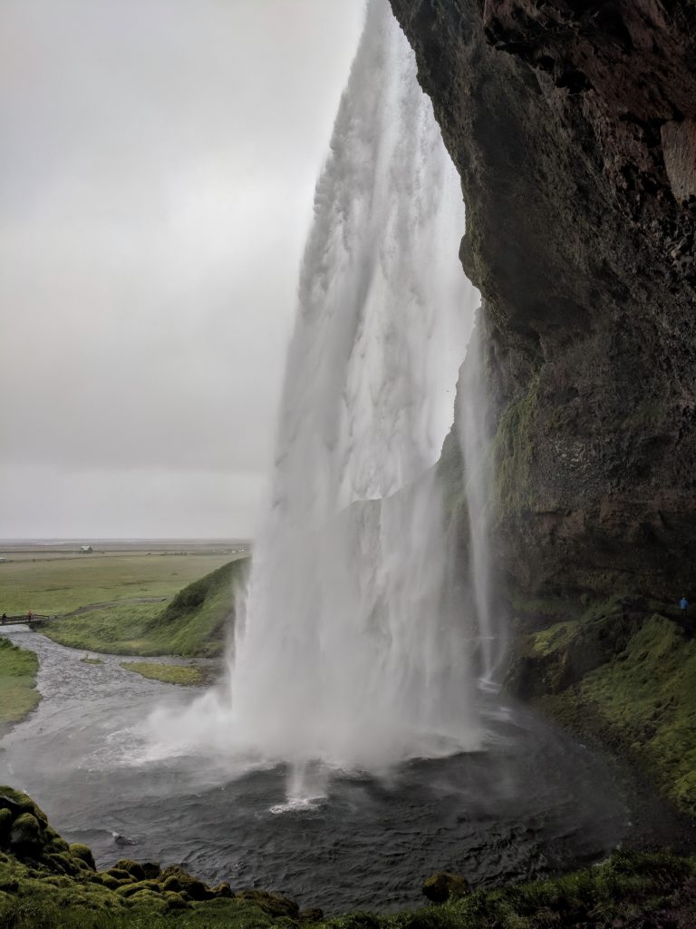
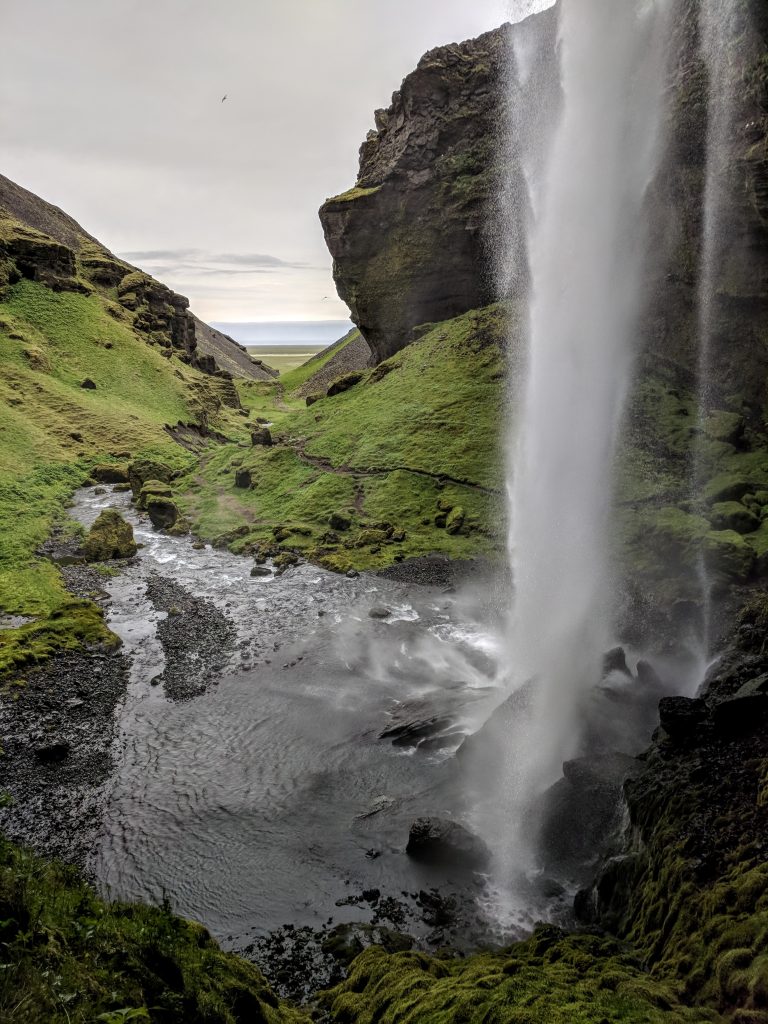
By the time we got there (25 min drive) it was really cloudy and rainy. We had enough time before the 10:10 bus to Thorsmork to walk to Gljufrabui, which is less than a half-mile from Seljalandsfoss along a signed, paved path. Another place that was far better than expected, highly recommend. The way the waterfall is shielded is awesome. Walked back to Seljalandsfoss and walked behind and around the waterfall. We weren’t too impressed because this was the first place where there were crowds, and the weather was pretty poor so there was no sky at all.
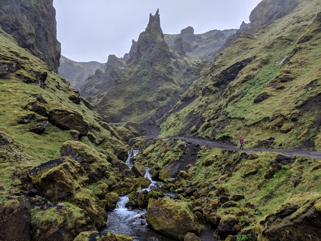
We took the Sterna bus into Thorsmork. It’s expensive ($50 USD pp) but the cheapest and easiest way to do the trail because it is one-way. The 15-mile hike from the Basar hut back to our car in Skogar was probably the best I’ve ever done. The scenery in Thormsork is unbelievable, and we didn’t see another person until about an hour into the hike. Tough ascent up the canyon in Thorsmork to the mountain pass, through snow fields, then back down to Skogar along “Waterfall Way,” which has over 25 waterfalls. Took us 7 hours 45 mins with stops for lunch and tons of pictures.
It wasn’t raining and although it had been a really long day already, there was plenty of light (not sun, of course – just light). I convinced my wife that we should take advantage of it and see more stuff, since it was showing rain all day the next day and we were leaving the area. I drove to the Skogar Museum and parked by the warehouses behind it.
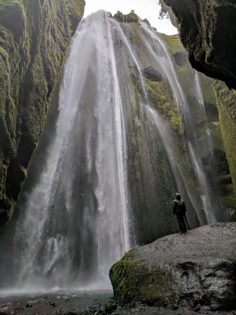
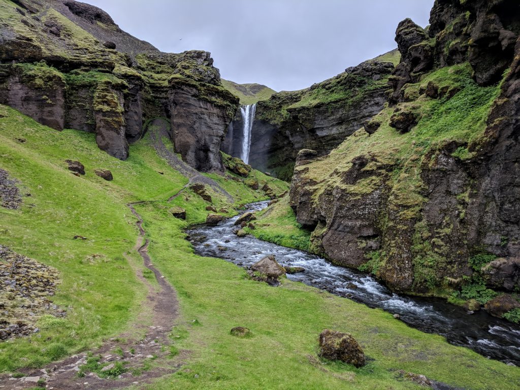
She opted to stay in the car, but I did the < 1 mile RT trek to Kvernufoss. I had the waterfall to myself for about 15 minutes. It’s like Seljalandsfoss since you can go behind it, but I think better because it’s at the end of a canyon and there are no crowds. To get there, you need to walk in the direction of the road that leads to the museum (heading east) until you run into the gated fence. Then head inland (left) and walk along the fence until you see a ladder that you can climb to get over the fence. The trail from there is easy.
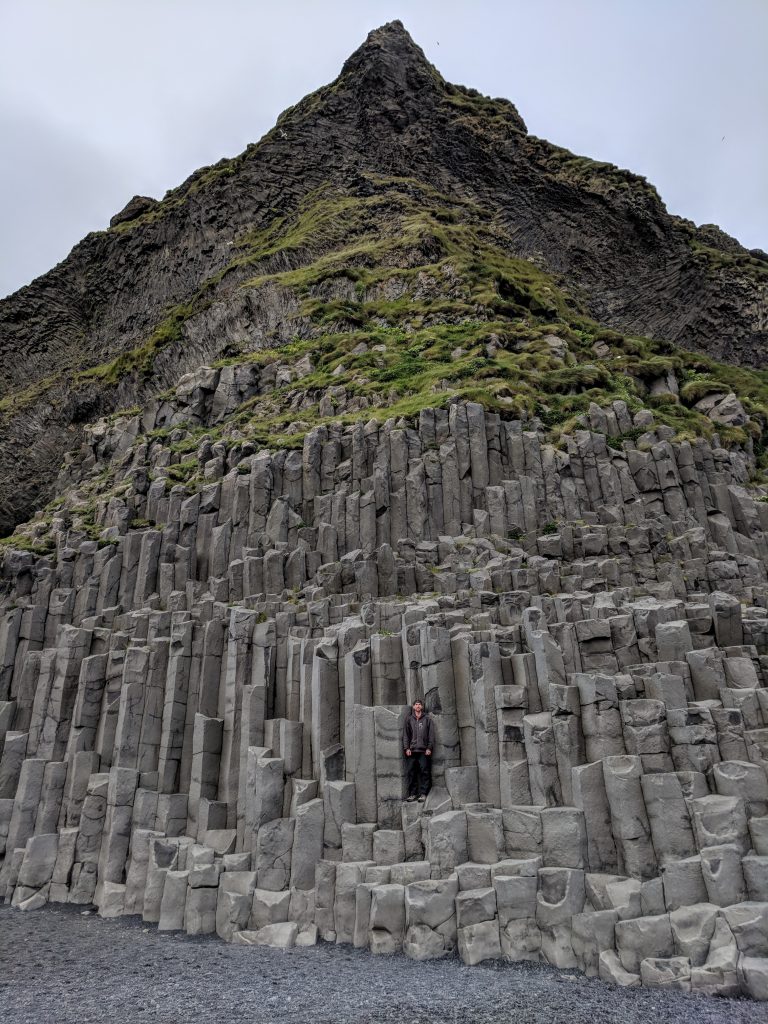
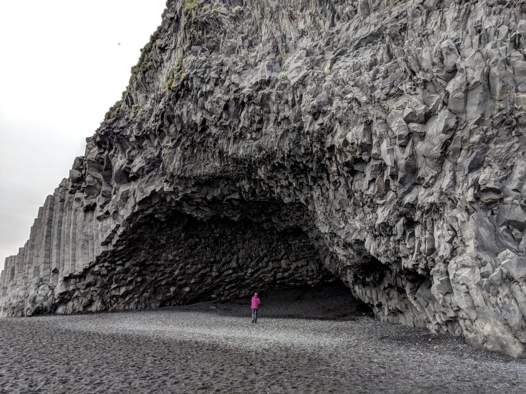
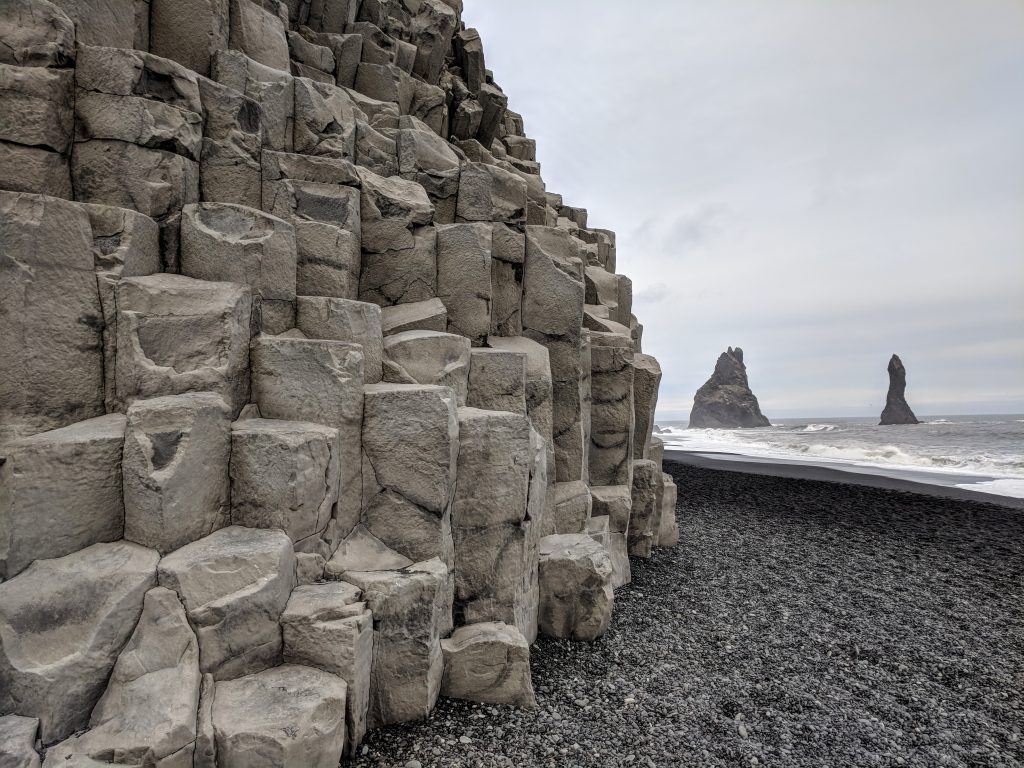
We drove to Dyrholaey to try and see the puffins, but Iceland decided to wait until we had already driven down the road a bit to let us know it was closed. Last stop was Reynisfjara, the black sand beach where you can see the basalt columns and sea stacks (although the better view of the sea stacks is from the other side, accessed from “downtown” Vik). This beach is a must-see and can be done in less than 30 minutes. Lots of people though, even that late. The tide was low so we were able to walk around the basalt columns to see the cave. What a day.
Day 4: Rain
- Þakgil
- Secret Lagoon Hot Spring
As predicted, the weather was pretty awful. We were in no hurry so we had a very slow morning and headed to Thakgil around 11. The road that gets you to Thakgil is very close to Vik, only about 5 minutes away, but it takes a while to get to the campground. Even in very little visibility and heavy rain, the drive down that road was fantastic.
If the weather wasn’t so bad and we hadn’t made day 3 such a long day, we probably would have hiked the yellow trail (or at least part of it – to get to the glacier is 17 km RT). We opted to just walk around for 30 minutes to get some pictures at the really cool spot by the campground (the place that reminds everyone of Lord of the Rings). Drove back to Vik to eat at The Soup Company in Vik (disappointing – just ok), then started the drive to Reykholt. Took a couple of hours, and it had been raining nonstop with no end in sight, so we checked in to our B&B.
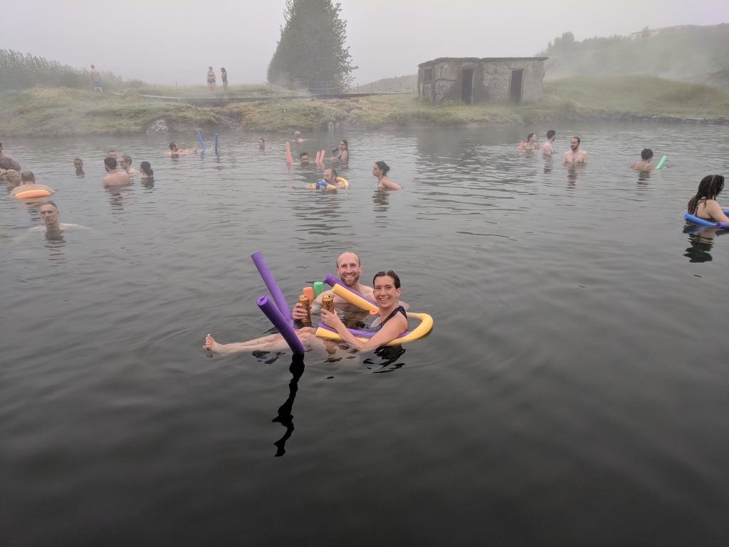
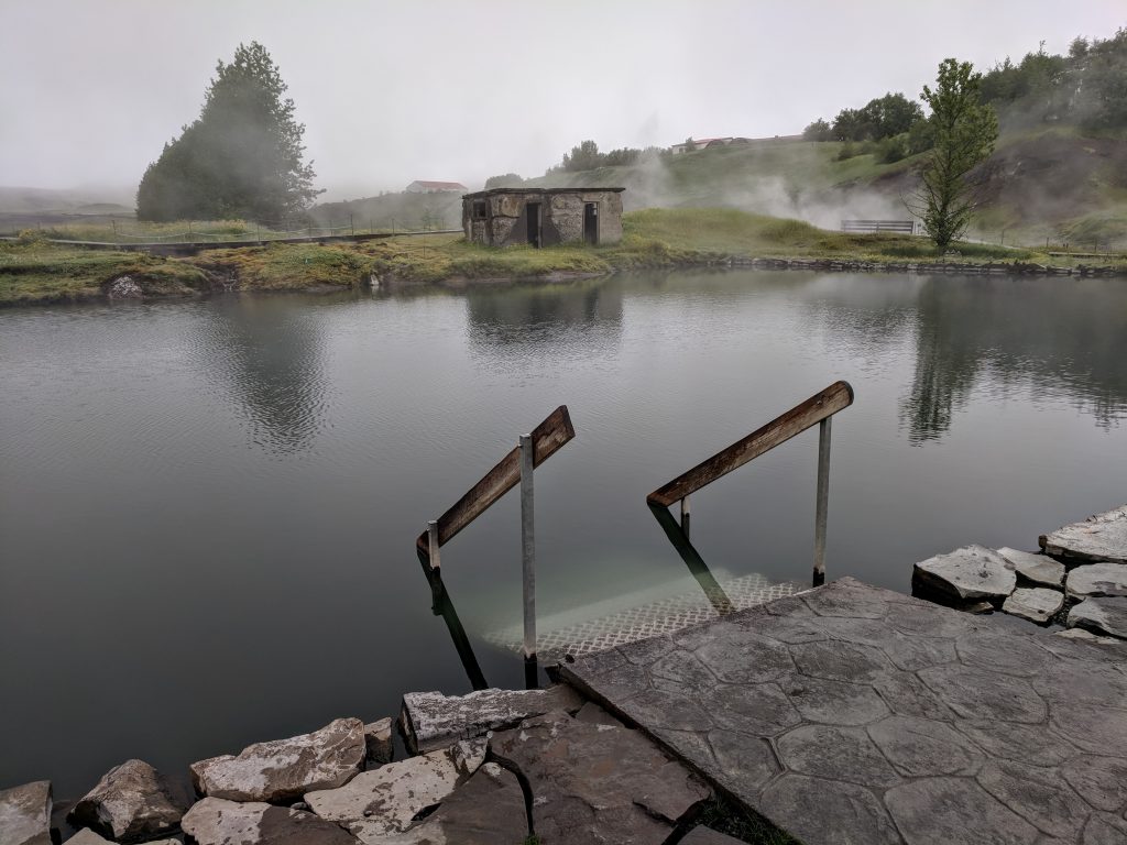
We stayed the next 3 nights at The White House Inn – another fantastic place. Huge, communal breakfasts with everything you can imagine, and it’s a great setup because you get to meet other travelers. The hosts and the property are amazing, too. Went down the street for dinner at Mika (great pizza) and then the Secret Lagoon hot spring, which was another 10 minutes away. We chose this instead of the Blue Lagoon – much more of a “hidden gem,” more authentic, and cheaper. Soaked for a couple hours, great experience. Yes, you do have to shower naked in front of others.
Day 5: Snaefellsnes Peninsula
- Ytri Tunga
- Bjarnarfoss
- Búðakirkja
- Arnarstapi
- Gatklettur
- Londrangar
- Kirkjufell
We picked Reykholt as our base for the second half of the Iceland trip. It’s in a good location to do day trips to the other areas we wanted to see. Our plan was to let the weather dictate where we went for the next few days, but it was showing rain everywhere. It showed the least amount of rain on the peninsula this day, so we made the 3-hour drive to the start of it and did it clockwise.
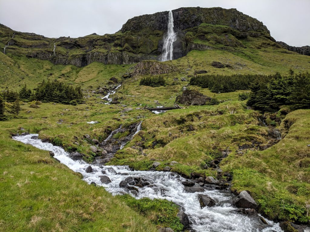
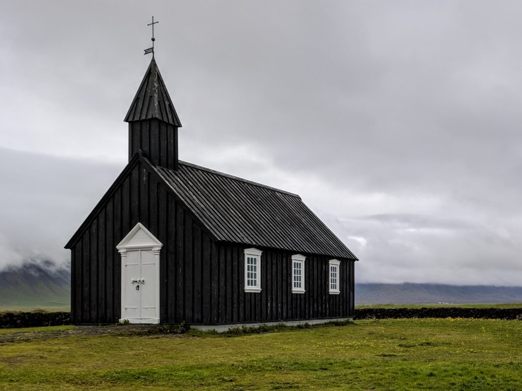
First stop was Ytri Tunga beach to see if we could spot some seals. Only saw one, it was really cold and windy, not worth the stop. The whole interior of the peninsula was covered in clouds and it was raining on and off, but there still was some beautiful scenery. Bjarnarfoss was next, and this is a tall waterfall coming off the top off a cliff/plateau. It seems like it’s on private property, but there is a parking lot and you can walk to the bridge at the base of the falls and explore further if you want. Must-see, 5-60 minutes depending on how far up you want to go. Budakirkja is the picturesque small black church, might as well stop since it takes only about 15 minutes.
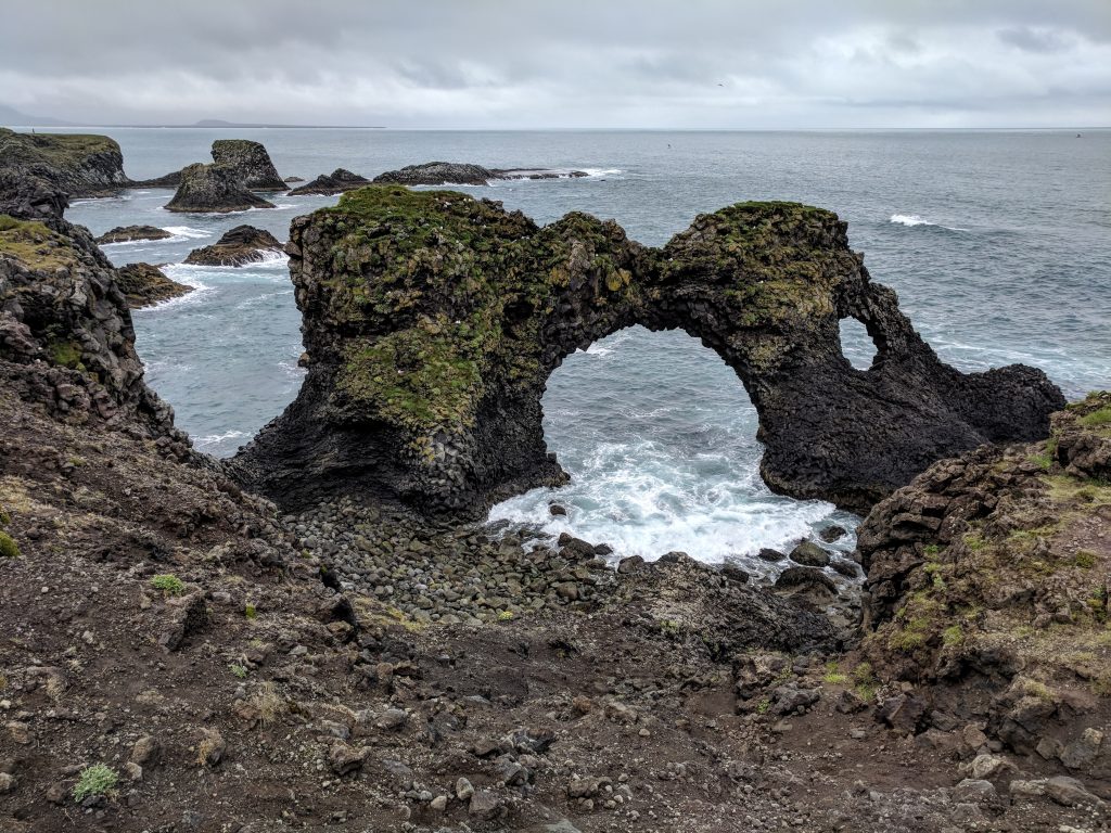
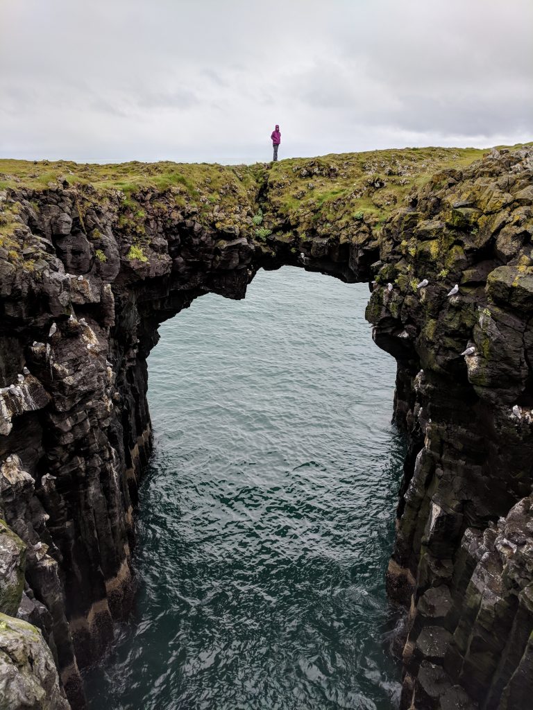
It was raining when we got to Arnarstapi, but it stopped long enough for us to have a great walk along the coast in the direction of Hellnar. Beautiful area and coastline. We walked to Gatklettur, which is the rock arch, and went back. Luckily the rain stopped for most of the walk, and it was our favorite part of the day (45 minutes total).
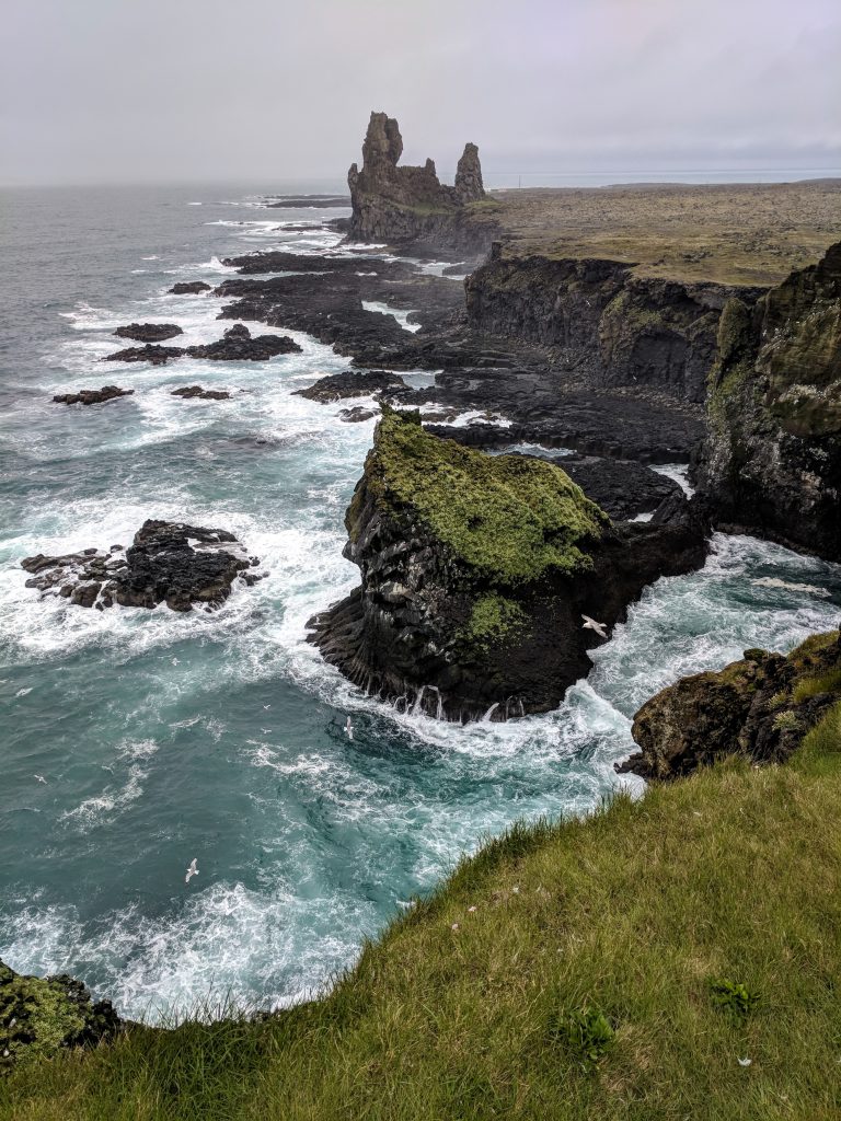
You can see the Londrangar rocks from the road, and you can pull off and walk to them. We opted to just take pictures from afar (short trail from the parking area), and then the road takes you around Snaefellsjoekull National Park.
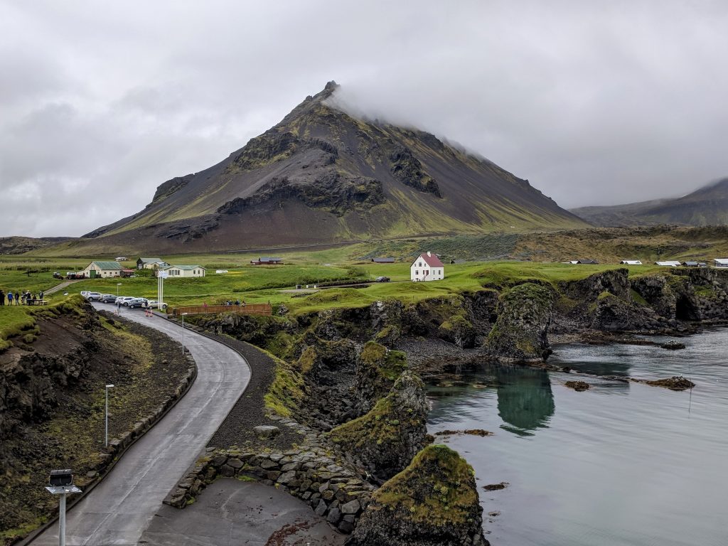
Kirkjufellsfoss was the very first thing I ever saw from Iceland, years ago, that put the country on my radar. There were a couple other stops we had planned but it looked like the rain was going to pick up in a bit. We skipped them and hightailed it straight to Kirkjufellsfoss. We miraculously had some blue in the sky when looking out to the coast. That view of the waterfalls (much smaller than you imagine) with the conical mountain is just as amazing as I had hoped. Grabbed some food in Grundar and then made the long drive back to our B&B. Skipped more things after Kirkjufellsfoss as well, as the rain had started.
They say the Snaefellsnes Peninsula is like all of Iceland in one section, and we felt that was pretty accurate. A lot of diversity and beautiful. Better weather would have been nice, but it was still 100% worth the long drive.
Day 6: Waterfalls
- Bruarfoss Waterfall
- Geysir
- Gullfoss
- Haifoss
- Gjáin
- Stöng, Viking-era Long house
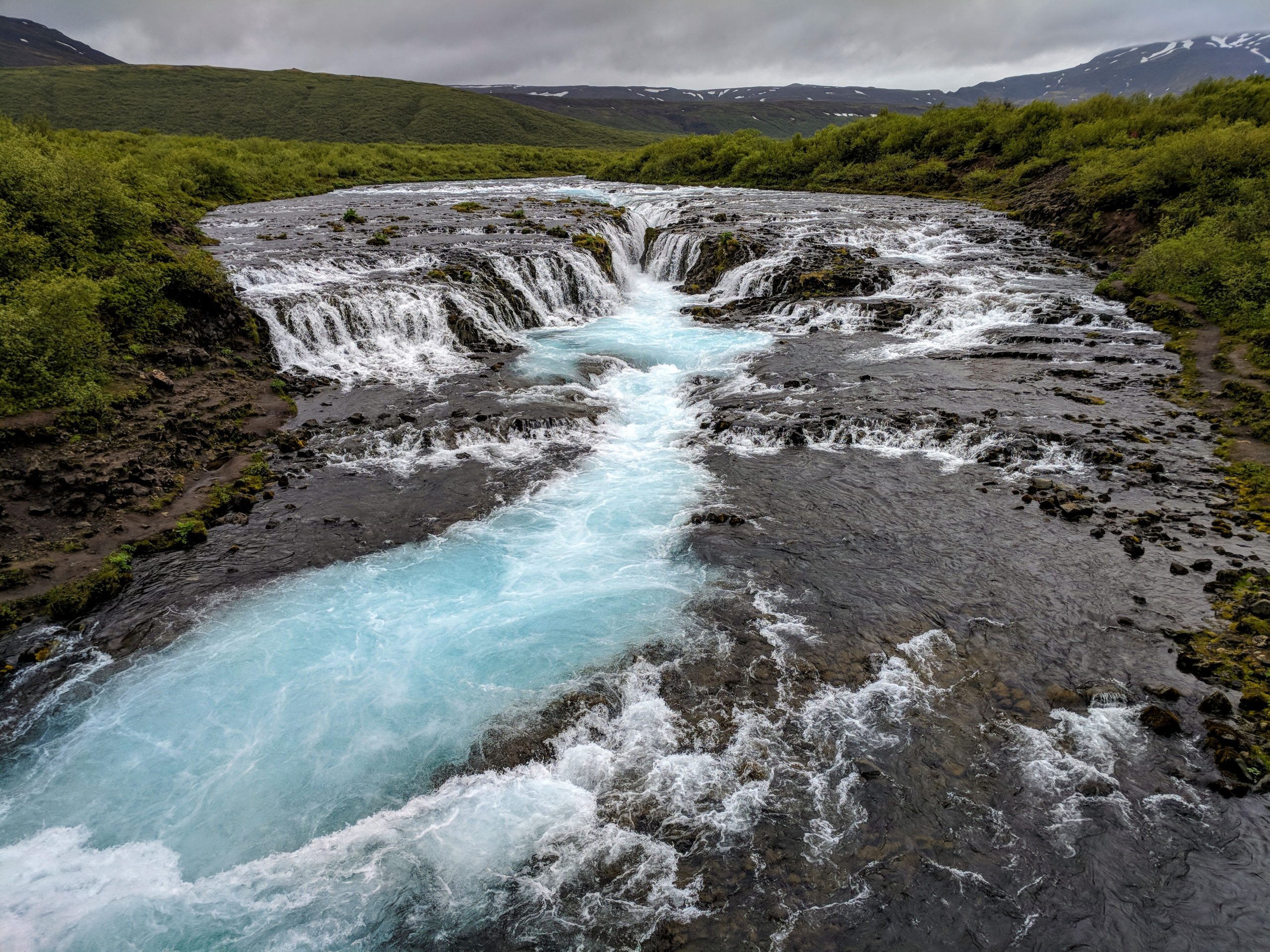
Rain again, and we first went to Bruarfoss (20 min drive). This is the unnaturally-blue waterfall and ended up being my wife’s favorite of the trip. Definitely worth it, but make sure to park where Google Maps says (and not where another traveler from your B&B says you should). It’s a 4.5 mile RT hike from there. No one there when we got there, but about 8 other people when we left.
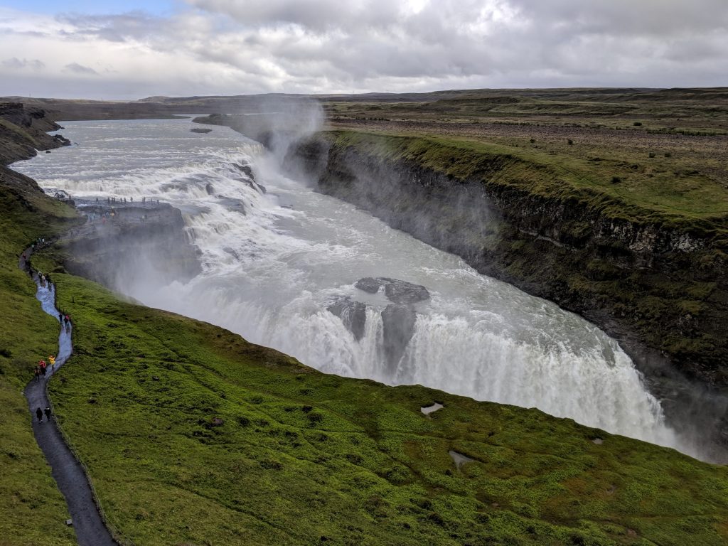
We then drove to Geysir (10 mins) and Gullfoss (another 15 mins). These are 2 of the most visited places in Iceland (maybe the most visited?). Geysir, Gullfoss, and Thingvellir National Park are the 3 main stops along the Golden Circle (some tours also include Kerid Crater). This is one of the most popular tours in Iceland and I can’t “dis”-recommend it enough. We completely skipped Thingvellir and Kerid because there are so many other better things to see and only went to Gullfoss and Geysir because they were close and don’t take much time.
We stayed at Geysir long enough to see it erupt and at Gullfoss just long enough to walk the trail to the different viewing points. Mostly rain and crowds, plus we weren’t too interested in the first place.
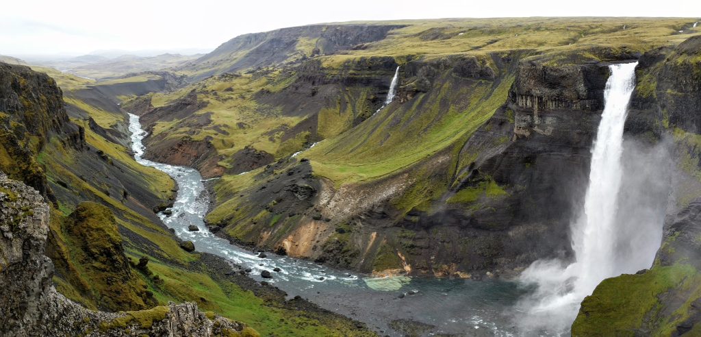
Then we drove to Haifoss, which we had planned on combining with Landmannalaugar because it’s kind of on the way. However, it’s only 1 hour 15 mins from our B&B so we knew on day 1 that we could see it later on the trip. The road to Haifoss is not well-marked – there is only a sign for something that isn’t Haifoss, and the road number (332) is not on there. We passed it, thinking that definitely wasn’t it, and once we were past the power plant we knew we went too far and that had to be it.
Basically it’s the closest turnoff west of the power plant, before you cross a bridge heading to Landmannalaugar. After you turn and drive on it for about a minute, you’ll see a sign that says Haifoss to the right and Gjain to the left. The road to Haifoss is really bad – would want a 4×4 for sure – and takes over 30 minutes.
After getting there, we were really glad we didn’t try to do it on day 1 because it would have added at least an hour and a half. Haifoss was one of my favorite waterfalls – it’s huge, powerful, and the view down the canyon is one of the best I’ve ever seen. There are a couple other waterfalls along that ridge, and the whole area is spectacular. It was raining, very windy, then snowed for a little bit when we got there. Waited it out, it stopped raining and the wind died down a bit so we could fully enjoy it.
Decided to extend the day and take that rough road (327) to Gjain, which I can only describe as a very pleasant, quiet, almost-hidden area with waterfalls, streams, and walking paths. Only one other group of 4 was there, and I just took pictures from above. If we had a lot of time, it’d be a nice area to stroll around. Continued down that road to Stong, which is an old Viking home. You can go in it to see how it was set up – neat, but don’t go out of your way just for that. Only spent about 10 mins total for the stop, then kept going on 327 until it met up with 32 and back to the B&B.
Day 7: Reykjavik
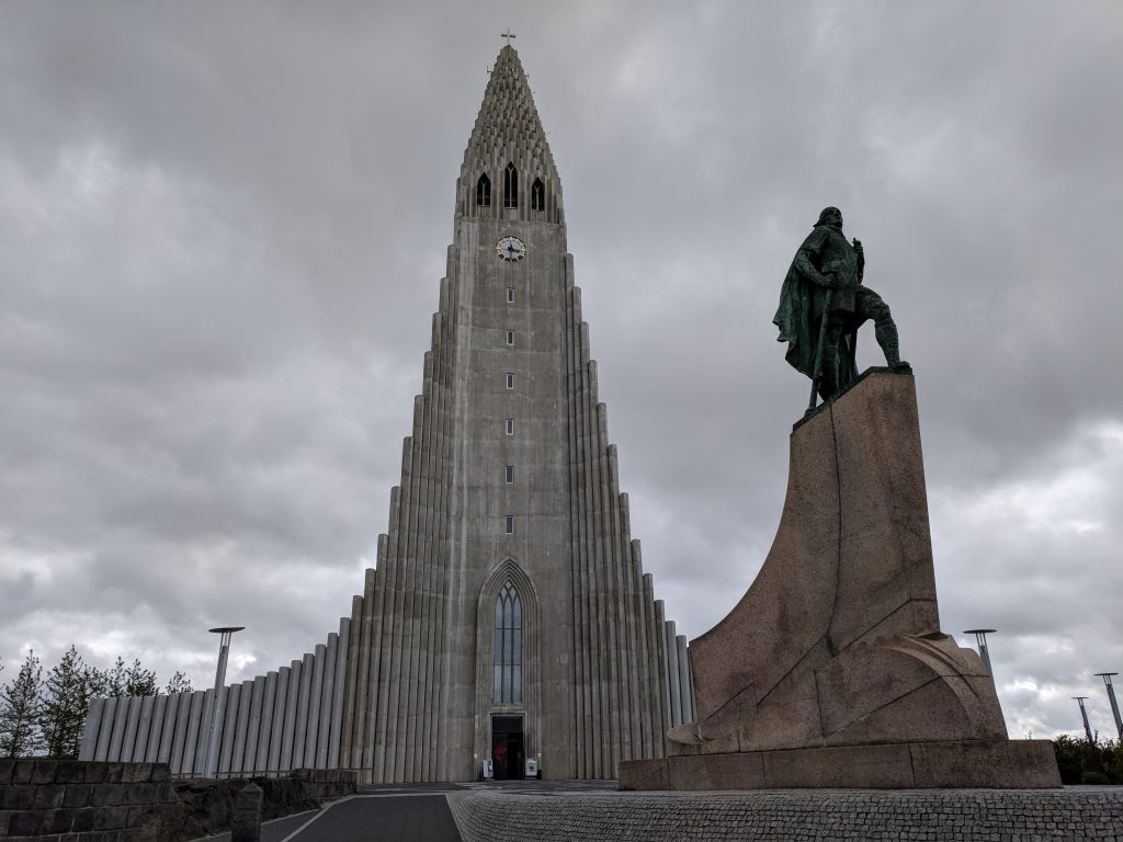
- Hallgrimskirkja
- Harpa Concert Hall and Conference Centre
- Sun Voyager
- Monument to the Unknown Bureaucrat
We weren’t in a hurry because it was raining again and we didn’t have a ton left to see. Drove to the parking garage in Reykjavik called Tradarkot, which ended up costing $5 and worked out great. We saw the Harpa Concert Hall (just from the outside) then walked up Skolavordustigur to Hallgrimskirkja. This is the street with the formidable view of the church at the end, and we stopped in many of the shops along the way. The church is one of the neatest-looking buildings I’ve ever seen. We didn’t pay to go up to the top – I’ve heard the views are great but we were content to just go inside and walk the whole way around it.
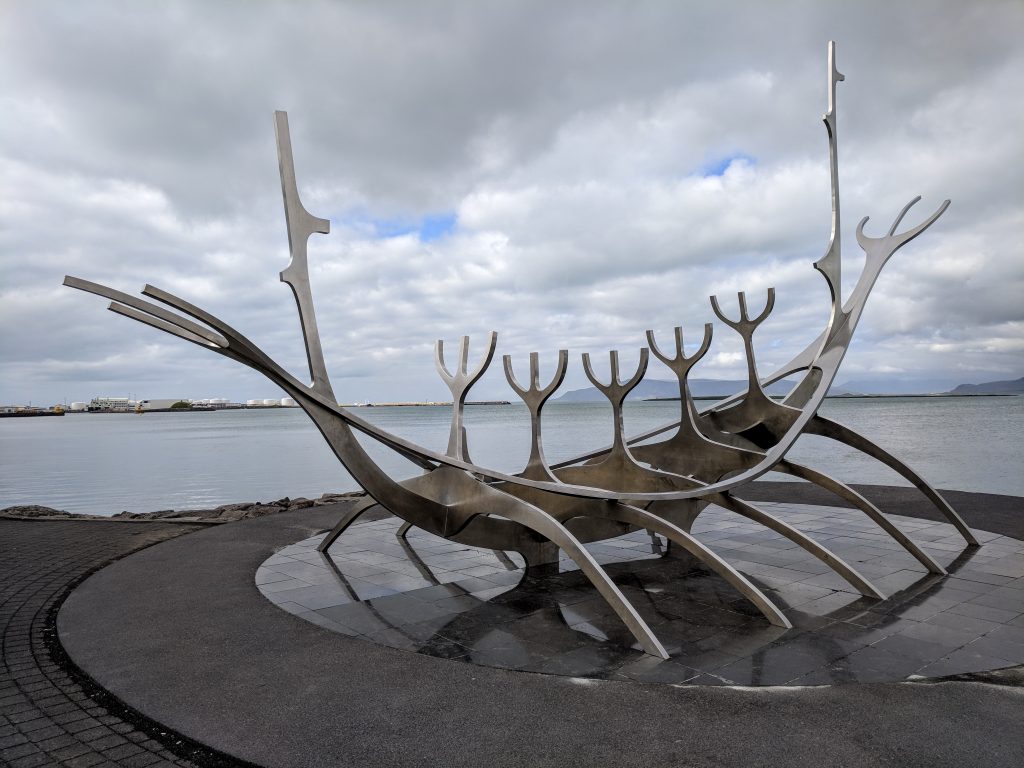
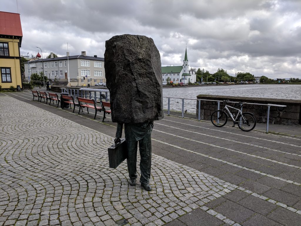
Walked to the Sun Voyager to take some pictures and then spent the rest of the day eating (Icelandic Street Food and Kebab Grill) and shopping. Laugavegur is the other main shopping street, and it intersects with Skolavordustigur. Had to see the Monument to the Unknown Bureaucrat. I consider the thought that we are all just pieces of a machine – nameless and faceless – as a reminder for how work can weigh you down. Remember to enjoy life. Reykjavik is a very walkable city, really liked our time there. Took the rental car back for our 9 PM flight home.
Additional thoughts
Iceland was my #1 destination in the world. I did more research and planning for this trip than I’ve ever done. It was definitely worthy of being #1, and I think waterfalls are now ruined for the rest of our lives. We never have to see another one, ever, after having been to Iceland. Since it took me so long to plan this trip, here are some other tips I learned:
Weather
Although our hosts said the weather had been much worse than normal for late June, we expected rain and clouds so it really wasn’t disappointing. Sure, more than 1 day of sun would have been nice. However, if we arrived one day later, we would have had no sunny days at all (the forecast when we left wasn’t looking any better). It rained a lot, but it didn’t really stop us from doing anything we wanted. Having 2 bases for several days each worked out great. We were able to be flexible and head in different directions based on the weather. But we were never too far from where we wanted to go the following day.
July and August are usually the nicest months in Iceland, but even then you can get crazy storms. The roads to the highlands usually open in mid-June. We were taking a chance arriving on June 20, but they were open. Temperatures for us were usually in the high 40s/low 50s. Obviously make sure you have waterproof everything and layers.
Car rental
We canceled and changed our rental car booking 4 times before we went. I kept finding better deals. I searched on Guide to Iceland and northbound.is (ended up keeping the one through northbound). We rented through Orange, which is about 8 minutes away from the airport (free shuttle). We didn’t have to wait more than 5 minutes for the van. Most rental car companies are offsite. Some are further than others, and reviews on a lot of them say ppl had to wait up to an hour for the shuttle. That is something I definitely wanted to avoid and was concerned about with some of the earlier bookings I made. Orange had great reviews and there were no complaints about the shuttle. Our 2012 Suzuki Jimny came with a free portable wifi, which was so useful, and free GPS, which wasn’t that great.
All rentals in Iceland come with CDW insurance, but I called Chase to see if I needed to decline it in order to have my Sapphire Reserve cover the insurance. I did, and verified ahead of time with Orange that I would be able to. There are several other types of insurance in Iceland (sand, ash, wind, etc.). They are usually all at a separate/additional cost, so I wanted to make sure I knew if my credit card would cover all of it and what I needed to do. They found a small crack in the windshield when I returned it. I had to pay a considerable amount out of pocket since I had insurance through my credit card, but I knew that was what would happen going in. I still would say it was a good experience with Orange and would highly recommend them.
If you’re going to the highlands, you need a vehicle with AWD. You can search for vehicles that are allowed on “F roads,” which are non-paved roads on which it’s illegal to drive without AWD. The Jimny got us everywhere we wanted to go and I thought it was fine.
Make sure you’re aware of the unmanned gas stations, especially if you’re driving outside of the “cities.” You’ll need a credit card with a PIN number. Chase doesn’t do that (as of this writing), so we had to use our debit card or buy prepaid gas cards at an N1 station. Otherwise you won’t be able to get gas.
Food
Food in Iceland is crazy expensive. We brought a lot of snacks from home with us to cut down on the amount of food we had to buy. Make sure to get groceries at Kronan or Bonus – by far the cheapest options. We ate a lot of pizza because it was one of the cheapest things, and filling. Soups, too, although we didn’t have any really good soups, unfortunately. Our B&Bs had huge breakfasts included, so we would usually eat as much as we could in the morning, have a snack for lunch, and buy dinner. Also, you don’t have to tip in Iceland.
Traveled in June 2018
Leave a reply