Guest post by dzr1107
Map tips: each color represents a different day. Click a marker to learn more about the spot, and click the star in the map header to save the entire map under Your Places in Google Maps.
We spent three days on Vancouver Island and three days in Whistler (both in British Columbia, Canada).
Day 1
- The Teahouse in Stanley Park
- Stanley Park
We arrived at Vancouver airport at 3:30pm. Customs was surprisingly fast- we actually waited longer for our bags than we did for customs. Traffic in Vancouver was congested, but not crazy. We stayed at the Sure Stay Best Western in North Vancouver, as it’s an easy 20 minute drive to Horseshoe Bay ferry terminal.
After checking in, we drove back to Stanley Park and took the first exit after Lions Gate Bridge to explore the western side. We parked at Third Beach and used their parking kiosk. It’s 3.60 CAD per hour and is based on your license plate number (so write it down because who actually knows that). You can add more time at any pay kiosk throughout the park which is very convenient. We walked the beach trail south towards The Teahouse. On a whim we asked the wait time, and were surprisingly sat right away at 6pm on a Saturday. The patio is less formal than inside in terms of what people were wearing. The food was very good and the view was excellent.
After dinner, we drove south around the park to get a view of downtown Vancouver, the totem poles, and the lighthouse. We had no issues parking or with crowds, but it was approaching dusk. There’s a lot of trails throughout the park and you could probably spend a day there, but we covered the key sights in 2 hours. The downtown view was my favorite, but it was cool to see all the boats and sulfur plant from the lighthouse.
Day 2
- Horseshoe Bay Ferry Terminal
- MacMillan Provincial Park
- Port Alberni
- Wickaninnish Inn
- Chesterman Beach
We booked our ferry tickets when we booked our airplane tickets. I checked the night before and all crossings to Nanaimo/Departure Bay were sold out until 8:30pm. Everyone we talked with on the trip asked first if we had ferry reservations, so call it highly recommended. You have a 30 minute window to show up and will not be let in outside of that window. From RT 1, follow the well marked signs to the toll booth where you pay for your reservation and get told a line. Once in line most people leave their cars to go to the washrooms along the way or get coffee at the village stores. You must be back at your car 30 minutes before departure time. On the boat Coastal Renaissance, decks 5&6 have cafes, gift shops, and indoor padded seating. We went up to deck 7, the top of the boat, and got front row seats in glass covered front. We saw humpback whales breaching towards Nanaimo. It was a smooth ride except for the boat vibration. As a person prone to boat motion sickness, I only experienced very mild discomfort with no medicine, while sitting. Walking around was slightly more unpleasant, but totally doable.
We got groceries at Nanaimo and stopped at MacMillan Provincial Park. It was raining, but still crowded. It’s divided into two easy, small loop trails on each side of RT 4 that do not take long to walk. The main attraction is a 800 year old Douglas Fir. It’s pretty, but you get the same feel on a lot of hikes on the island.
We got lunch in Port Alberni and filled up with gas, as it’s the last place to get gas until the Ucluelet/Tofino junction.
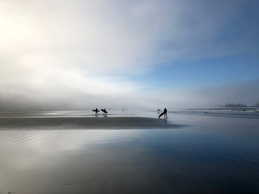
We stayed at the Wickaninnish Inn, which is absolutely lovely. It’s upscale, but still down to earth. It’s also at the northern end of Chesterman Beach, a long curved beach that’s popular with surfers, despite air temps in the 60s. It’s my favorite of all the beaches we visited.
Day 3
- Chesterman Beach
- Tonquin Trail
- Chocolate Tofino
At low tide, we walked Chesterman Beach to is neighboring island, Frank Island. You can not actually go on Frank Island as it’s private property; however, along the public rock line you can find starfish.
We had brunch at The Pointe restaurant in the Wick. It requires reservations and more formal attire in the evenings, but is open with a relaxed dress code for breakfast and lunch each day. It’s a nice way to enjoy the views and good food without the pomp and circumstance, unless that’s your thing.
Tofino is very bike friendly, so we used hotel bikes to bike into town (15-20 min). There are a few different places to rent bikes if need be. The downtown has several bike racks to lock your bike, making it easier than driving and trying to find (very limited) parking. It has some cute restaurants and stores and does not feel overly touristy, despite catering to tourists. We left our bikes and walked over to the Tonquin trailhead by the community center (also the safe building for tsunamis). There’s a discrepancy between google maps and the posted signs, but we took the trail to Tonquin beach – a smaller, more local beach- and then along the coast to Middle Beach or Third Beach, depending on what map you use. The trail is mostly forested and is not along the beach. There’s more elevation changes than I expected, but nothing bad. The walk took us around an hour and we rewarded ourselves with some amazing gelato at Chocolate Tofino. If it’s busy, there are two entrances- one facing the road and one in the back.
Day 4
- Mackenzie Beach Public Access
- Tacofino
- Ucluelet
- Wildside Grill
Mackenzie Beach is located on the northern side of Chesterman Beach, so we headed up there on bikes after breakfast. It’s more sandy than Chesterman and had a lot of people walking. It looked like a cute hotel with beachfront cottages, which might be a nice place to stay.
We had lunch at the very busy, and very delicious Tacofino. This is a food truck tucked in the very back of the property that’s shared with Chocolate Tofino and other stores south of town. It took awhile to get food at 1:30pm on a Tuesday, but well worth it. The gringas are small, get at least two. We finished our tacos with dessert at Chocolate Tofino (again, yes).
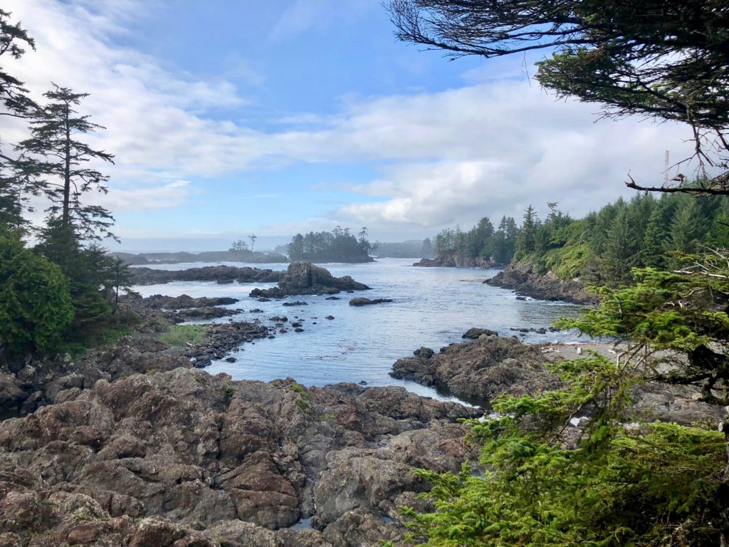
We drove about 40 minutes down to Ucluelet and parked on Coast Guard Rd for the Lighthouse Trail. It was our original goal to do this trail, part of the Wild Pacific Trail, and the Rainforest Trail, but we never made it. It took us about 3 hours to do this 2.6km loop, but we took a TON of pictures of waves hitting the rocky coast. It was gorgeous. While both surf towns, Ucluelet seems a little more rugged than Tofino, both on the coast and the downtown. Ucluelet was a good visit, and I wish we did the Wild Pacific Trail, but I’d stay in Tofino again.
We got delicious burgers for takeout at the Wildside Grill, which is in the same food plaza as Tacofino, and drum roll, Chocolate Tofino. There’s also outdoor seating under lights if you prefer to eat there.
Day 5
- Boomerangs Cafe
- Departure Bay
- Sea To Sky Highway
- Brandywine Falls Provincial Park
- Nita Lake Lodge
We left at 7:30am for a 1:15pm ferry due to construction on Rt 4 that’s scheduled to be done fall of 2020. The construction hold up was only 35 minutes, so we grabbed “brekkies” at the Boomerangs Cafe in Port Alberni. Very cute spot.
Departure Bay is a smaller port, but they still have washrooms on the left and a market with coffee, touristy souvenirs, and chocolates on the right (down towards the water). We were on the smaller Queen of Oak Bay, which only had one passenger deck and one sun deck. The upper decks of cars vibrated less, so I took the opportunity to nap on the 1.5 hour crossing.
The Sea to Sky highway driving time is around 2 hours, but you should stop on the way up. They have a few pullouts, but they’re predominantly on the southbound side. Going north, you have more parks than pullouts. I stopped at Shannon Falls PP on an earlier trip, but we skipped it this time. If you have time, do it, but my favorite is Brandywine Falls. It’s a short walk from the ample parking lot to the waterfall. Sunlight is best in the morning, so you can see the undercut of the ground beneath the trees, but it’s still stunning in the afternoon. The trail ends with an overlook of Daisy Lake and the back of Black Tusk. It’s a great view, except from some pesky transmission lines across the lake.
We stayed at Nita Lake Lodge, in Whistler Creekside. It’s calmer and less congested than Whistler proper. They also have a complimentary on-demand shuttle to drop you off in Whistler so you don’t have to worry about parking. There’s more shopping and food options in Whistler, but Creekside was fine for us.
Day 6
- Panorama Ridge
- Garibaldi Lake
- Creekbread
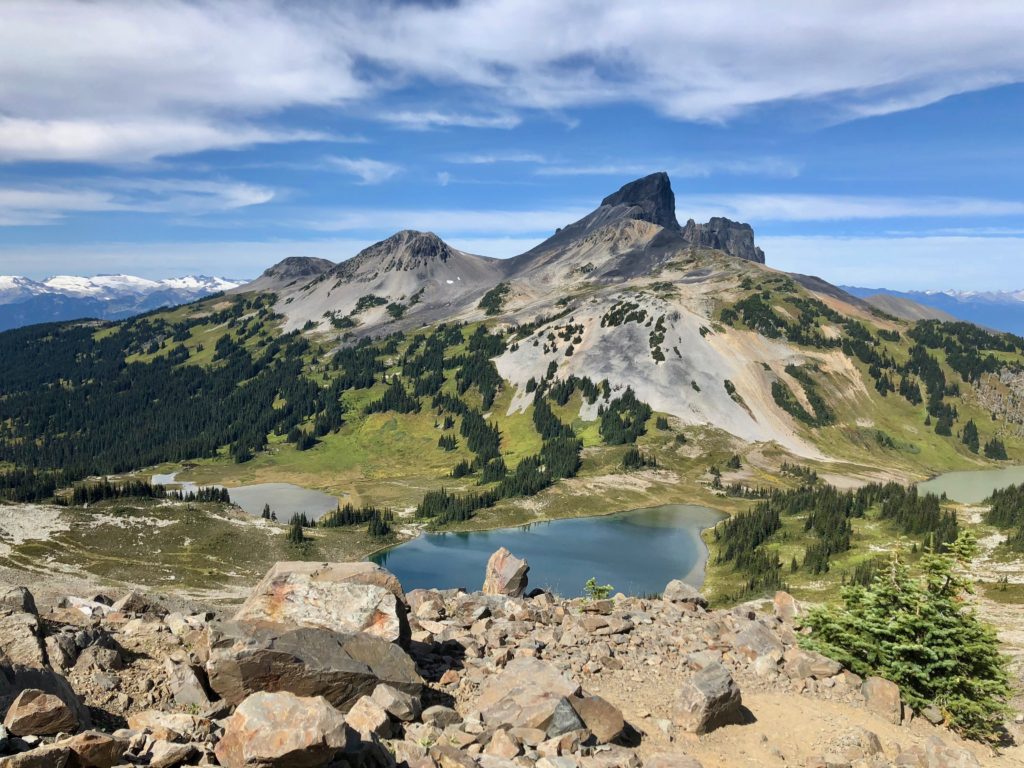
Having relatively fresh legs (the only way to survive), we hiked the Panoramic Ridge Trail. Our finishing stats were 21 miles, 376 flights of stairs, and 12 hours and 10 minutes. We took our time but didn’t linger. Lots of locals passed us and one jerk even was running this trail. We clapped.
It’s difficult, but it’s amazing and once my legs fully recover, I’d do it again in a heartbeat.
We got to the Rubble Creek Trailhead -20 min south of Creekside- at 7:30 am and the parking lot was 1/3-1/2 full. It’s the trailhead for Garbaldi Lake, Panoramic Ridge, and Black Tusk. The trail starts off for in the woods with no views for the first 5 or so miles (except forest and the occasional deer). You start immediately into switch backs that vaguely make you question what you’re doing. It’ll change to a gradual incline before the second set of switchbacks start and seemingly never end. Ever. You’re insane for doing this but you can’t turn back now because there aren’t any “views,” so it’s all in vain if you do.
6km in, there’s the “6km junction” with an outhouse and a split to Garbaldi Lake or the Ridge/Black Tusk viaTaylor Meadows. We chose to go through the meadows because we figured if we went to the lake first we wouldn’t want to keep going up the mountain. I still maintain it’s the best way to go. However, you still have switch backs to get to the meadow. You’ll know you are there when you walk on a boardwalk into the campgrounds, which conveniently has a water source, outhouses, and a shelter.
Relax a little, because while it’s still uphill, it’s gradual enough it feels like nothing. You also can get views of mountains behind you and start to get a view of Black Tusk on the left. If you’re really lucky, you’ll run across bears eating the blueberries in the meadows. Be alert. The group ahead of us didn’t notice the two black bears about 30 feet from the trail. Thankfully they didn’t seem to care about us, although the feeling was not mutual. After the meadows, the trail for Black Tusk splits off to the left. Go straight.
After a little more walking through trees, you’ll see a lake and start getting into the really good views that make this walk worthwhile. You can’t see the trail, but you can see the ridge you’ll walk, but don’t look for it. It’s better if you don’t know yet. The trail meanders and eventually reaches another junction for Cheakamus Lake. You’ll go off to the right and then down the hill to the left. And then back up, don’t worry. Still climbing.
Once you reach the rocky area of the trail, you’ve officially reached the hardest part. Hopefully you’ve repressed the second set of switchbacks and are more acclimated to altitude. The trail is slightly defined but is a bit of a scramble for the last mile, more so the higher you go. I have nothing nice to say about it, but you’ve got this. You can do it!
The top shows the amazing 360 view of Black Tusk, the valley, and surrounding mountains (like Whistler and Blackcomb) you’ve been enjoying on your “gasping for air” breaks, and it shows Garbaldi Lake in all its glory, and another glacier covered mountain. Garbaldi Lake rivals the color of Lake Moraine over in Alberta. The views are worth it.
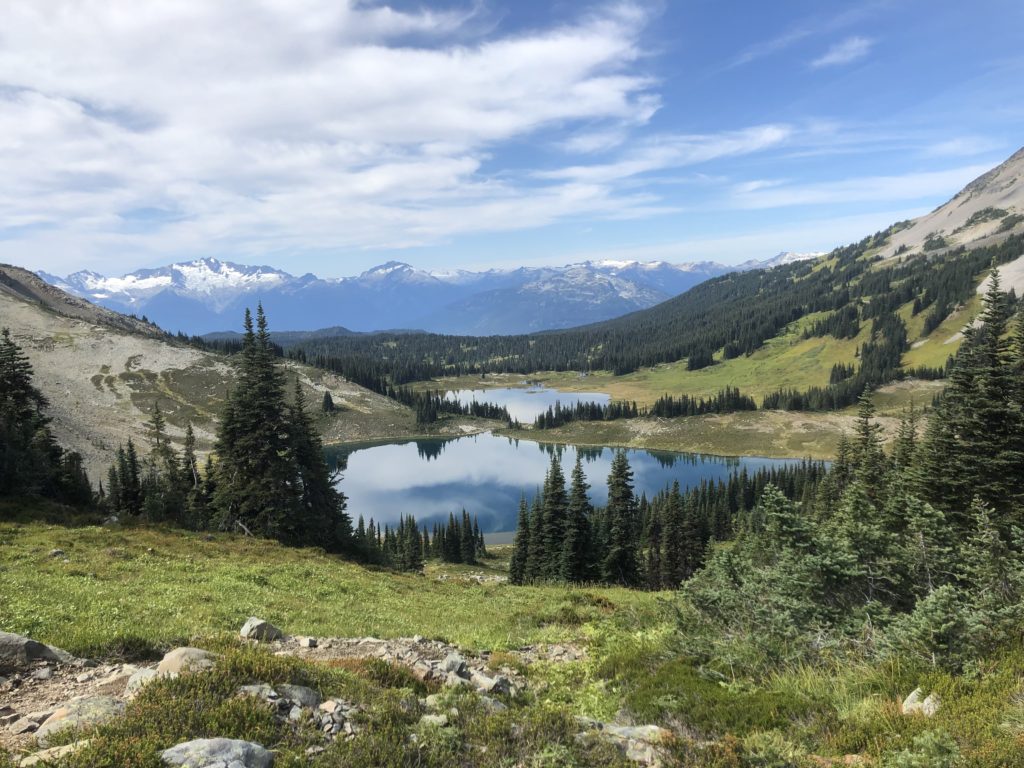
We had a hard turnaround time to get off the mountain and retraced our steps until the lake trail split. It adds just one more km to go see the lake, so you might as well. It’s all (mostly) downhill from here. The lake is gorgeous and kids were swimming in early September. There’s outhouses at the campground, but no potable water. From the bridge you’re about 10km from the parking lot. The lower trail takes you along two more lakes, Lesser Garbaldi, and Barrier Lake, but you don’t get much visibility from the trail. You have the option of overlooking the Barrier, but we didn’t take the 100m detour.
We got Creekbread pizza, which was delicious and much needed after the hike.
Day 7
- Whistler Mountain
- Blackcomb Peak
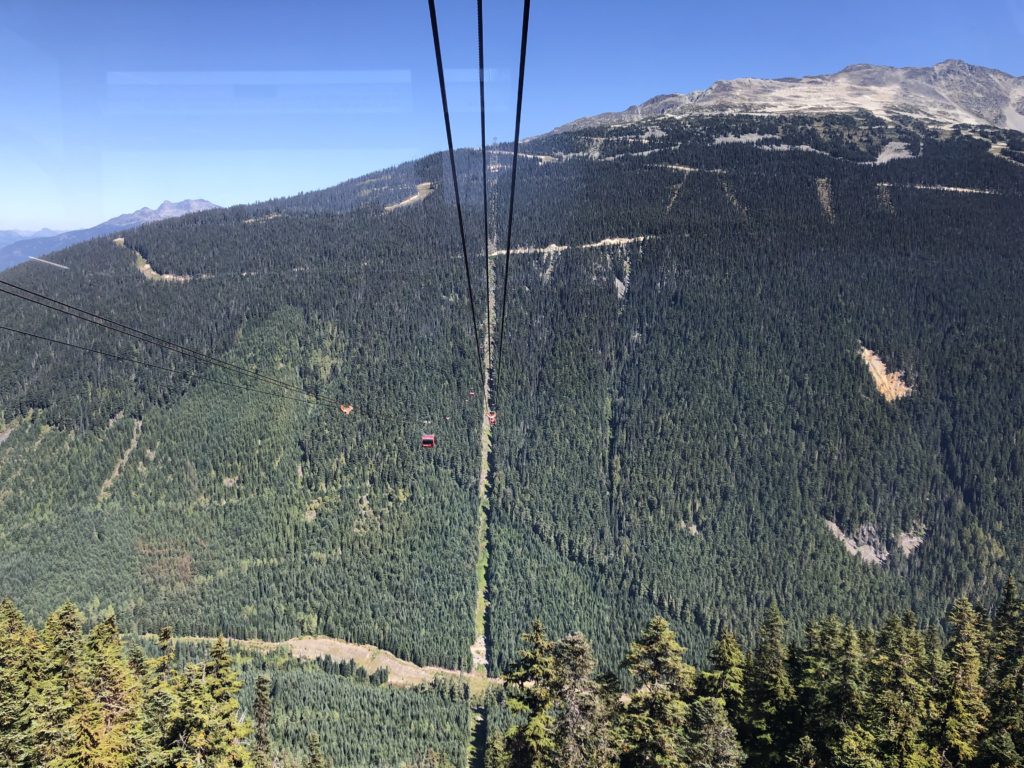
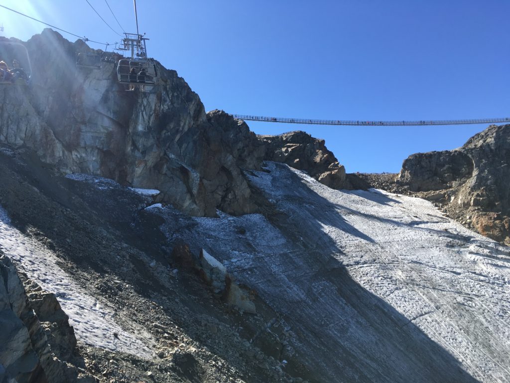
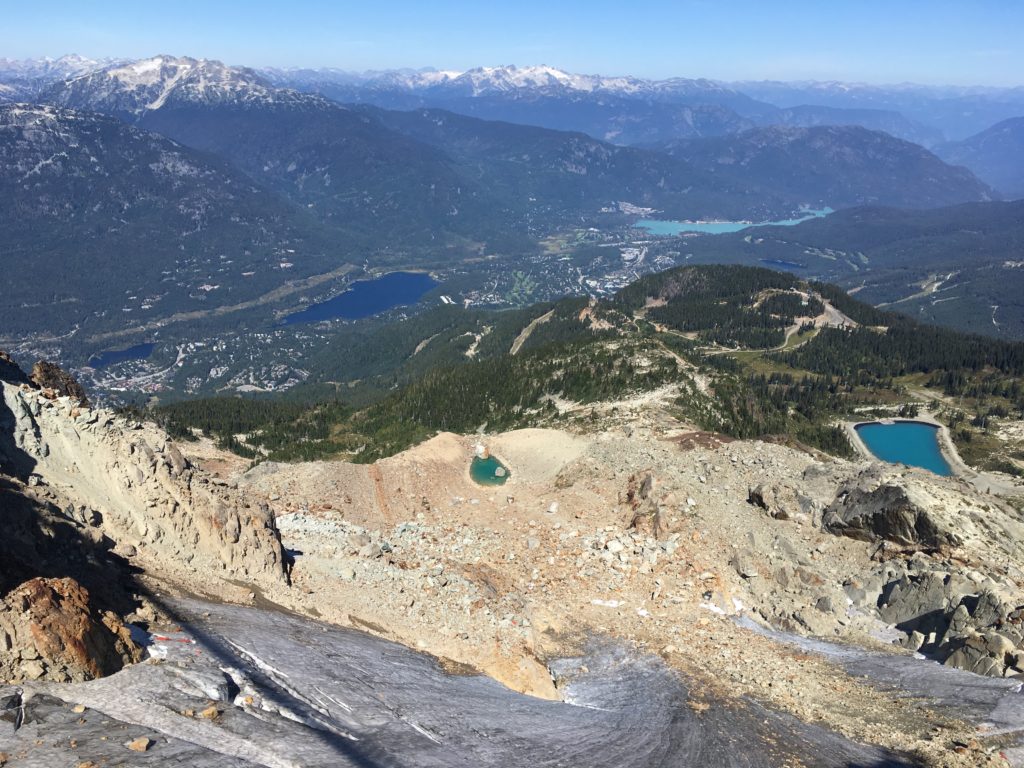
It was a light walking day. We got tickets for the Whistler Gondola, which includes tickets for the peak lift, the suspension bridge, Peak to Peak gondola, and the Blackcomb gondola. We went up Whistler, took the photo ops with the Olympic Rings, and continued on a short trail over to the Peak Lift, which takes you to the very top, the suspension bridge, and the stone statue. After doing the bridge -it doesn’t move as much as it should- over the bowl people actually ski, we took the Peak Lift down and walked over to the Peak to Peak gondola. You have the option of waiting for the limited glass bottom car with 17 of your new friends, or you can take a regular car. We did this for no wait and still got a very good feeling for exactly how high up we were.
There’s less at the top at Blackcomb, but so we got lunch at their cafe and took in the mountain views before heading down their gondola.
Back at base, we walked over to Whistler Village and checked out shops and restaurants throughout the village.
We ate a delicious dinner at the Cure cafe at Nita Lake Lodge. The buttermilk ranch chicken was amazing.
Day 8
- Pemberton
- Lillooet Lake
The RBC GranFondo, a 4500 person bike race that stretches from Vancouver to Whistler was today. We cheered on the professional bikers who reached Creekside just after 10am. Amateurs came after, and they had all of Rt 99 closed or heavily delayed until then.
As a result, we went north and drove the Sea to Sky highway’s end in Pemberton. We continued on 99 to Lillooet Lake with one inadvertent detour: you have to turn right on 99 before the Chevron, otherwise you continue on the reservation and will end up in Birken. We pulled off the side of the road and admired the lake before heading back to the Vancouver Fairmount airport hotel. We caught early morning flights the next day and flew to our perspective homes.
Traveled in September 2019
Leave a reply