Guest post by dzr1107
Map tips: each color represents a different day. Click a marker to learn more about the spot, and click the star in the map header to save the entire map under Your Places in Google Maps.
Day 1
We began our trip early afternoon by heading out of San Jose on 101 S, across California on 152 E, and up to Yosemite National Park on 41 N. The length of the trip took us about 4-4.5 hours, with stops for lunch and grocery shopping. After channeling my inner New Yorker to get through the San Jose traffic, the trip became much more relaxing on 152. The middle of California is filled with miles and miles of produce fields and trees and appeared to be rather poverty stricken, but perhaps it was just the burned out desperation from the record-breaking drought. We stopped at a grocery store in Madera, CA and loaded up on groceries for the few days we’d spend inside Yosemite NP. They sell coolers, so we purchased one of those to keep the dairy products cool. This is the last largest city before the park, although there is a small convenience store in Wawona.
We stayed at a great house inside the park that rented reasonably on VRBO. There are several rentals in Yosemite West and this location not only bypasses wait times at the entrance stations, but puts you 10-25 minutes from the heart and soul of Yosemite.
Day 2
- Glacier Point Trailhead
- Sentinel Dome
- Taft Point
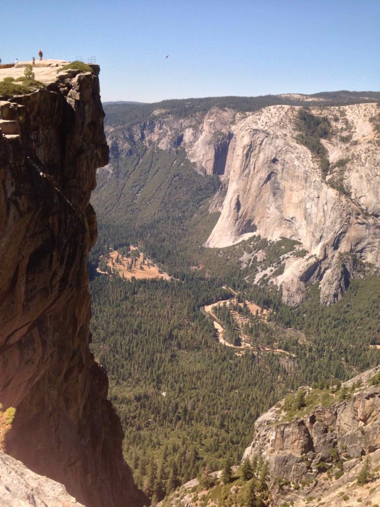
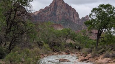
This day focused solely on Glacier Point, which is accessed by turning right onto Glacier Point Road (aptly named). There are restrooms at the turn that I believe have water, everything else was outhouse quality. There are not many views along the road until Washburn Point, which provides a parking lot and panoramic views of Half Dome. At the end of Glacier Point Road, there is a large winding parking lot with well maintained walking paths (aka Glacier Point Trail) to various lookout points. We arrived early to mid morning and the point had several people there, but it was not crowded. We could still get several pictures without stranger photobombs. Glacier Point is a great all-ages overview area that does not require much exertion or hiking.
After spending an hour or so at the point, we back tracked down Glacier Point Road to the Sentinel Dome Parking lot. The parking lot is essentially in the middle of Sentinel Dome and Taft Point, so you can either see one without the other, back track to see both, or take the 4.15 mile loop that hits both without overlap. We opted for the latter, starting out towards Sentinel Dome. The trail was pretty easy until the base of Sentinel Dome, which is a large dome rock jutting out of this nice forested area. One of our trip members decided not to climb the dome due to health issues, but it looks more intimidating than it actually is. At the top of the dome, we were treated to a breathtaking panorama that showed Half Dome, the valley floor, El Captain, the Cathedral Spires, etc. I am not sure if you could see Yosemite Falls, as there was no falls when we visited (drought). It is worth going to the top of the dome.
We then descended Sentinel Dome, and dropped below and around the dome on the Sentinel Dome/Taft Point trail. This was easy hiking with crisp forest air. Taft Point is a cliff point that provides great views of El Captain and the valley floor. Once we approached the point, there were several large holes (for lack of a better word), where the cliff had eroded. They are easy to avoid, but pay attention to the path. At the actual point, there is a steel guard rail that serves to provide some psychological assurance to the faint of heart. It is a significant drop off and our one traveler who is afraid of heights did not appreciate the downwards view.
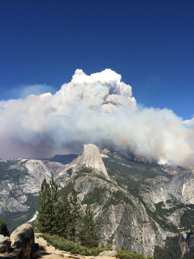
We finished the hike and went back to Washburn Point to view Half Point. While this will not occur on most visits, it just so happened that during the course of this day, the Meadow Fire grew from 19 acres to 4400 acres, causing a large smoke plumb behind Half Dome. Hikers around Half Dome had to be evacuated off the top by helicopter.
Day 3
- Tunnel View
- Tenaya Lake
- Olmsted Point
- Merced Groves Trail Head
- Washburn Point
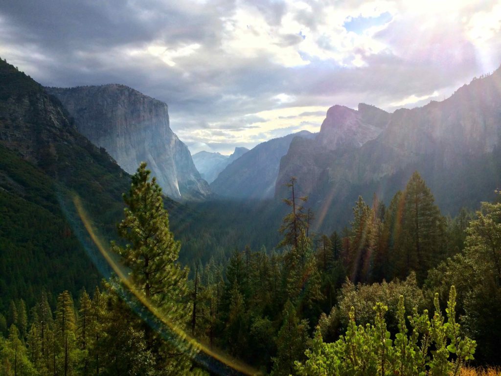
Around 9 am we drove to Tunnel View, which when coming from the south, is a tunnel (surprise!) followed by a parking lot and views of El Captain and the Cathedral Spires. It is worth the stop for photos, and timed with a sunrise or a cloudy day with a few crepuscular rays, is spectacular. You must continue driving into the valley (the road splits and creates a one-way around the valley) and cut across select bridges to go the opposite way. We passed El Captain, which is very impressive when viewed from the valley floor. We also spent more time than I’d like to admit looking through our camera’s zoom lens to try and find crazy rock climbers on El Captain.
We drove out of the valley and to the north area of the park on Tioga Road, which is closed from November to May. It is a scenic drive with a few places to pull over and admire the view. Tioga Road goes across the entire park; however, we only went to Tenaya Lake. This is a very pretty lake set in the mountains with a slight beach that you can walk along the lake. There were only a handful of people there, including a couple who works in the park and considers Tenaya Lake their secret gem. We did not spend a long time here because smoke from the fire was filling into the area, but would be a nice picnic area.
On our way back to the valley, we stopped at Olmstead Point. This is a must-see if you are on the Tioga Rd. There is an initial view point, but also a trail that should not be missed. It starts by going down rock stairs from the parking lot. It is short (maybe 1 mile RT) and leads you out to a giant rock slab with large boulders where you can frolic around and better see the view behind Half Dome (opposite Washburn Point). Most people just go to the view point and do not do this trail. Don’t make their mistake.
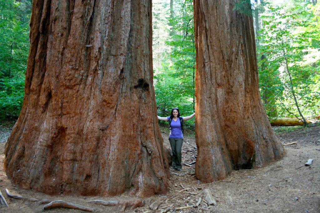
We then stopped at Merced Grove of the Giant Sequoias, as our attempt to see ridiculously giant trees without stopping at Mariposa (closed until 2017 for restoration). This was a 3 mile RT hike, with a significant 1.5 descent – the easy part – and conversely, a 1.5 mile ascent – the hard part. It is a mostly forested trail, but it was still enjoyable due to the crispness of the fresh air. At the bottom of the hill/mountain (the trail continues on to El Portal), we saw the big-bomber trees. There were about 5 of them. I personally don’t consider this a “grove,” but if you’re in good shape and like photo-ops, it’s pretty fun to take a bunch of perspective shots and marvel at how incredibly wide, tall, and old these sequoias are.
We ended this day by driving back to Washburn Point to witness the sunset and full moon rising over half moon. If there is a full moon, I recommend doing this, but it is a somewhat sketchy drive down the road in the dark. (Disclaimer: I have a full fledge fear of hitting deer/other animals in the dark).
Day 4
- Dewey Point
- Crocker Point
- Stanford Point
- Tunnel View
This is a very long hike (11 miles), but provides good views and gives you a good sense of accomplishment. It is also sparsely populated, as we hiked much of the trail without passing anyone (but did see a bear print).
We were dropped off at the trailhead on Glacier Point Road. The pull off does not entirely match the start of the trail, so we actually started down what we thought was the trail but quickly realized it was not. The real trail has a rusted sign warning you of snow and gives you a run down of mileage. We opted to hike to each point and then descended to Tunnel View (and our ride home). We passed some people who decided to start at Tunnel View and climb up. I find this certifiably insane, but give them props.
The trail starts off pretty easy and flat across a pretty meadow and into the forest. Once we emerged from the forest, we arrived at Dewey Point. This is a pretty spectacular view looking down onto the Cathedral Spires and El Capitan. The trail continues winding along the edge of the cliff/mountain to Crocker Point and Stanford Point. These views are also impressive, but are essentially the same view as Dewey Point but further and further away. If pressed for time, I’d just hike to Dewey Point and back. After Stanford Point, the trail descends with a moderate slope to Tunnel View. About halfway (?) down, we reached an old driveway and markers for Inspiration Point. We detoured to what we thought was Inspiration Point, but it certainly wasn’t inspiring or had much of a point. The entire hike took us approximately 6 hours.
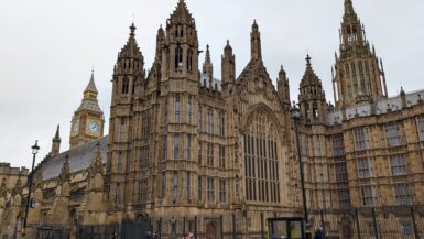
After getting picked up, we headed into the heart of the valley and stopped at the Ahwahnee Hotel. The valley floor has a fair amount of people and is pretty congested. There are showers, campgrounds, gift shops, overpriced food stores, and the hotel. The Ahwahnee itself was a nice stop to marvel at the architecture and admire how perfectly it fits its environment. It would be enjoyable to stay at the Ahwahnee, but I still prefer the location of Yosemite West to the Glacier Point hikes and activities. However, I might change my mind if there was enough water for the waterfalls.
Day 5
- Hearst Castle
- Cambria
Having hiked for the duration of the day, this was a travel day. We left Yosemite NP and drove 3.5 hours on 41 over to 46 to reach the coast. We then toured the Hearst Castle at San Simeon, CA.
Hearst Castle is very interesting – from the building, the story, the parties, the decadence, etc. You park at a visitor center that has some food and restroom options, and then take a shuttle up to Hearst Castle based on tour group. The shuttle ride provides background history and glimpses of the remnants of Hearst’s exotic animal collection (the zebras hang out near the Super 8). We took the Grand Rooms tour. I personally prefer to be set loose and not adhere to tours, but the tour was not bad and gave a glimpse into the history of each room. No expense was spared. After the tour, we were allowed to walk the grounds outside of the castle at our leisure. It provides very panoramic views and lots of time to realize your entire worth probably wouldn’t even buy the guest house.
We spend the night in Cambria at the Little Sur Inn, a very cute, comfortable, and clean inn across the road from the beach and nestled between lots of restaurant options. I’d definitely go back.
Day 6
- Moonstone Beach
- Point Piedras Blancas
- Willow Creek Picnic Area and Beach
- Carmel-by-the-Sea
We stopped at Moonstone Beach early in the morning. It is a nice walking beach; however there was a morning fog and the air was surprisingly chilly so we did not stay long. We continued driving north on the infamous RT 1. Unfortunately much of the views were blocked by sea fog, so we didn’t get the views and true appreciation for the coastal beauty as we were expecting. It would be nice to go back with clear views and see the coast. We stopped at Point Piedras Blancas, a nice boardwalk overview of the coast and dozens of resting sea lions. They apparently come to the beach yearly at this time. We also, on accident, stopped at the Willow Creek area of Los Padres National Forest. It’s a narrow road that descends to the water, but there are pretty good views of the coast, a rocky beach, and a bridge. There are several pull offs on Rt 1, which we used to either let people pass us or take in a break of the fog. At one pull off we did see whales in the distance.
We spent the night in Carmel, a very quaint and expensive town. We walked downtown to the crescent beach. It is very scenic and part of it meets the Pebble Beach golf course.
Day 7
- Point Lobos State Natural Reserve
- Coast Guard Pier
We started another chilly overcast day with a visit to Point Lobos State Reserve. We arrived early (maybe 9am) because there are a finite amount of parking spaces and it does get full. We found it to be a very scenic park, with nice trails leading us in and out of jetties, view points, and beaches. There was enough sea life (sea lions and otters, perhaps) to keep the journey interesting. A few people said they spotted whales, but we did not see them. We spent approximately 2 hours here and sufficiently saw the park.
We then started our drive back to San Jose to catch our flights the next day. We went into Pacific Grove and stopped at Lover’s Point Park. Parking was difficult to find, so once we found a spot, we walked to the point to check out the coastline and then up into the town to have lunch. We drove into Monterey to drive by Fisherman’s Wharf, however the traffic pattern was a little confusing and it was congested traffic so we skimmed past downtown and the wharf. Once we were able to catch a breath, we found a larger parking lot attached to Coast Guard Pier. This is a long pier along the water with dozens (maybe hundreds) of resting and swimming sea lions. It’s pretty cool and the keep out signs from the Coast Guard make you feel like you’re living dangerously.
Since we still had time to kill and we were traveling with a golfer, we opted for the 17-mile drive. There is a fee for the drive ($9-$10), but it is worth it to watch the golfer in your life light up like a giddy little kid. The drive is entertaining for non golfers. It gives you an opportunity to visit several famous golf courses, each with varying dress codes. We stopped in at the Spanish Bay Club and caught a bag piper that walks in each day to signal the close of the course. The 17-mile also includes the infamous Pebble Beach Golf course. We visited a few shops at Pebble Beach, including the overpriced pro shop. Overall, if you have any knowledge or interest in golf, it’s worth doing the drive. Depending on how many courses you visit or how long you visit, this could take several hours to do. I think it took us about 2-3 hours.
Traveled in September 2014
Leave a reply