
The most important thing on this page: please follow the 7 principles of Leave No Trace whenever hiking (and all the time, actually – most are pretty good general life tips, too):
- Plan ahead and prepare
- Travel and camp on durable surfaces
- Dispose of waste properly
- Leave what you find
- Minimize campfire impacts
- Respect wildlife
- Be considerate of other visitors
Now, on to Lago di Sorapis. Here are the quick facts:
- Where: Dolomites, northern Italy
- More specifically, where: the trailhead is on SR48, 10 minutes east of Cortina d’Ampezzo
- Distance and elevation: 6.75 miles (11 km) roundtrip with 1,550 feet (475 meters) of elevation gain. Doing the loop around the lake adds 0.8 miles (1.3 km) and 125 feet (40 meters) of elevation gain.
- Highest point: 6,400 feet (1,950 meters) along the loop around the lake
- Why you should hike this trail: arguably the most beautiful alpine lake in the world on a relatively easy, shorter trail
- Fee or permit? no
- Best time of year: mid-June – September
- Closest commercial airport: Venice, Italy is a 2-hour drive
Tips
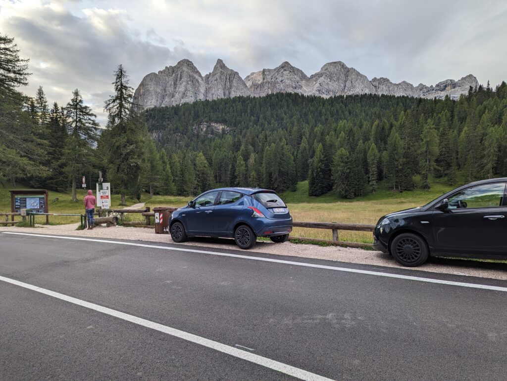
- Get there early – preferably parking at first light
- Absolutely, 100% do the loop around the lake
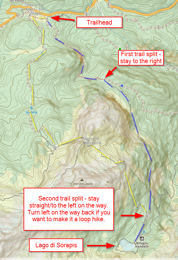
- Remember to follow signs for Rifugio Vandelli, as Sorapis is not mentioned on some of the trail markers
- The rocks along the main path can be very slick and the ground very muddy if recently wet
- There is a longer and harder route you can take on the way back to avoid the crowds
- There is no swimming in or camping by the lake
- Bring your patience: there will be tons of people
Getting there
The trailhead is clearly marked on Google Maps along SR48 in Cortina d’Ampezzo. You may see references to the hike starting at “Passo Tre Croci,” which is the mountain pass right by the trailhead.
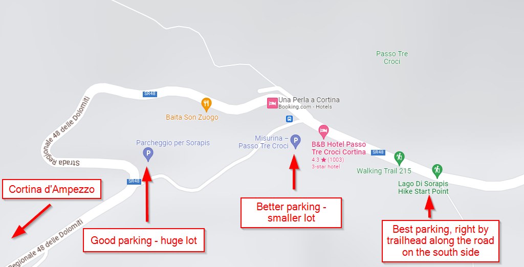
While there are buses that run from Cortina to Passo Tre Croci, I recommend having a rental car to make the most of your time in the Dolomites. Since the trailhead was less than a 15-minute drive from our lodging in Cortina (Dolomiti Lodge Alvera – excellent), we were able to get a spot right at the start at 6:50 am.
Trailhead to Lago di Sorapis (3.4 miles)
While Lago di Sorapis is mentioned on the placard at the trailhead, it is not on all of the trail markers. You’ll want to follow signs for trail 215 that leads to Rifugio Vandelli, which is just steps off the main trail right before the lake.
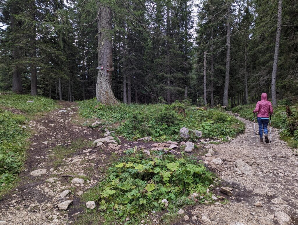
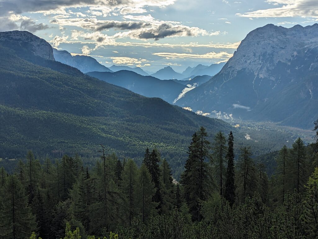
The trail starts on a wide gravel path but soon turns into dirt and rocks as it narrows. You’ll gently descend for the first 0.7 miles then head uphill. The trail is mostly through the woods but there are stretches where it’s open and you can see across the valley. If you’re not planning on returning this way (more on that later), make sure you turn around from time to time as there are some towering peaks behind you.
There is a split at about 1.25 miles, and you might get confused if you forget to follow the trail that leads to Rifugio Vandelli. Take the path to the right to stay on trail 215 heading towards the rifugio and lake.
The incline gets a little more aggressive (still not very strenuous, however) and the views really open up.
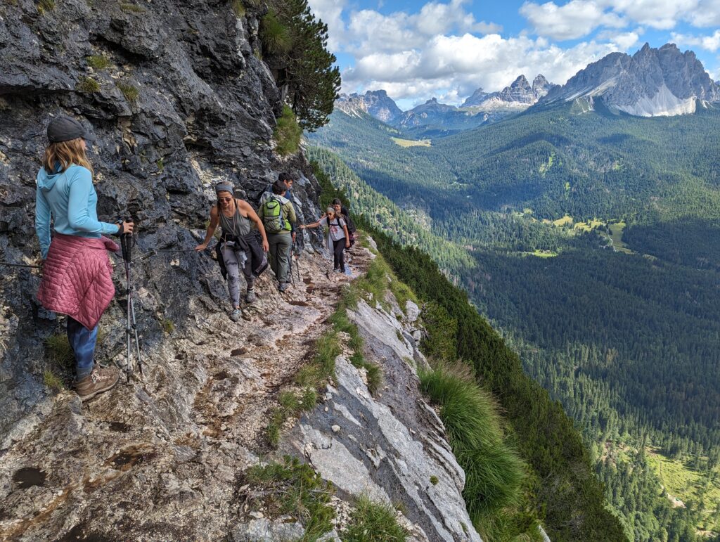
At 2.5 miles you’ll get to the first of several sections with cables. There’s only one stretch where the path is quite narrow with a “game-over” drop on the one side. There are chains to hold on to, however, and there are also some metal stairs in a couple of spots.
The trail goes back under the canopy after the cables and stairs. Just over 3 miles from the trailhead is another trail split with an option to go to the right. The sign at this intersection does have the word “Sorapis” and it points to the left. Only 0.4 miles to go until the lake!
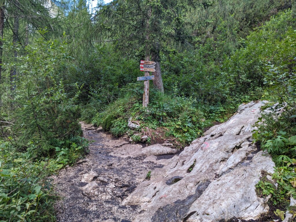
Another 0.25 miles after the intersection immediately above is another one. There are lots of markings and you can tell which way the lake is even though you can’t see it. Going left will take you to Rifugio Vandelli in less than 1 minute and going right will take you to the lake in 2-3 minutes. It took us just over 1.5 hours to get from the trailhead to the lake.
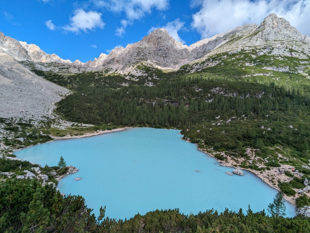
At and around Lago di Sorapis
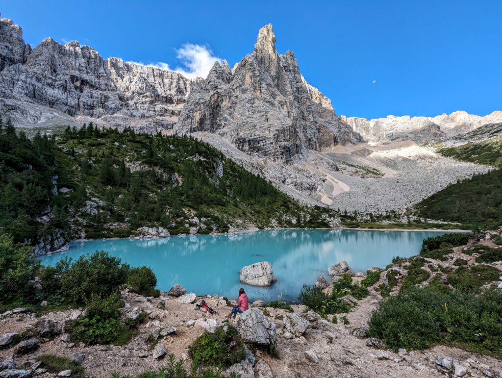
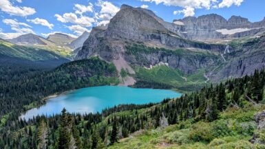
Your first glimpse will be the best view: directly across the blue-green water is the Finger of God (Dito di Dio) towering above. There is one very distinct, large rock that makes an interesting foreground in pictures. I’ve seen photos of people on it thanks to a rock “bridge” or the water level being so low they could walk right to it. However, it is forbidden to get in the water so please keep the lake pristine and don’t go out if it means getting wet. There’s another rock right on the shoreline that makes for what I think is an even better picture.
There was already a handful of people scattered around the lake at 8:30 when we arrived, but we were able to easily get our pictures without anyone else in them or having to wait. We also got there just before the sun had fully crested the mountains so we got to see the water change colors.
After getting a few pictures together with a tripod, we sat down for breakfast and enjoyed the scenery. We miraculously had a moment where everyone cleared out of the immediate area and we seemed to have the lake all to ourselves. This was an experience and moment I’ll always remember.
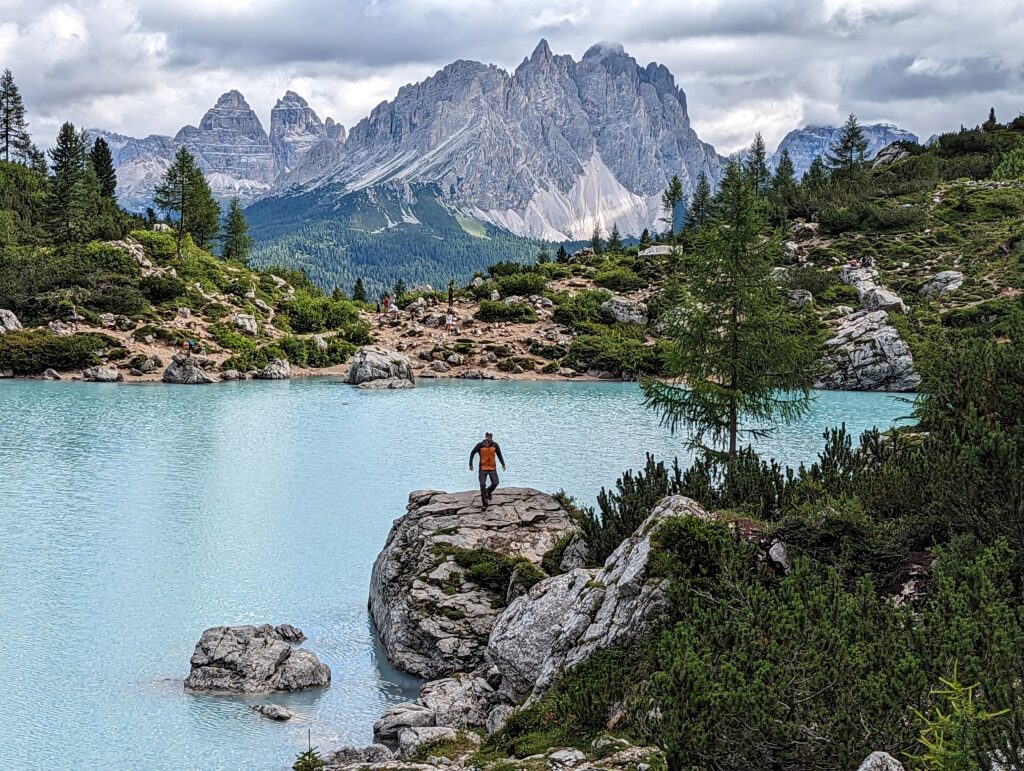
It didn’t last long, however, as people began arriving consistently when we were ready to do the 0.8 miles around the lake. The loop trail should not be skipped and is easiest to follow by going counter-clockwise. It’s flat until about 75% of the way around when you have to ascend about 125 feet to get above and around a cliff that goes into the water. Just before the ascent starts, there’s a stunning view of the water with Tre Cime and the Cadini group in the background.
You could do the loop clockwise, but that would entail an aggressive ascent right at the start. There are also lots of social trails at the start of that side. They should all lead you to the right place but it might be confusing which one to take. Some might be more difficult than others, too. Going counter-clockwise and coming down that area is much easier because you can see exactly where you’re going to end up.
Lago di Sorapis back to the trailhead
There were lots of people by the time we finished our lap around the water. We took the same trail back to our car and I cannot overstate how many people were heading to the lake on our return trip. It seemed like a never-ending line and we had to stop many times on the wire, ladder, and narrow sections. We saw so many ruined white sneakers because of the mud – make sure you wear hiking boots. Because of how slow we had to go on the descent, it took us almost as long as the way up.
If you have time and/or want to avoid the crowds, take trail 216 that will now be on your left 0.4 miles after heading back from the lake. You’ll pass Forcella Marcoira then turn right on 213. From what I’ve read, it’s an aggressive incline that is tougher than anything you’d have done on your way to Sorapis. It doesn’t add too much mileage but it will take longer and adds about 1,000 feet of elevation gain. We didn’t do this and don’t have any regrets. I didn’t think the views were worth it and we had so much more we wanted to do in the afternoon because the previous 2 days had been very rainy.
This is possibly the most popular trail we’ve ever hiked, and it makes sense. It is free, there is plenty of parking, the hike is relatively easy, and the lake is one of the most beautiful places on earth. Unless you want to be sharing the trail and lake with hundreds of other people, I’d suggest starting at or before 7. You’ll be fighting crowds on the way back on the main trail, but it’s better than getting stuck on the way behind people you can’t pass.
That’s it! Have you ever done this hike, or have any questions? Please leave a comment below.
Leave a reply